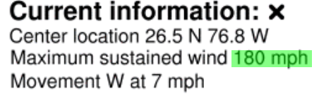
Not sure what NHC will do officially at the next advisory, but this is likely a strong category 5 hurricane now. Recent aircraft observations have shown 175mph wind.
I realize I'm no longer local, but would appreciate any guidance for Myrtle Beach, SC. If you have time/knowledge/interest.
Heavy cat 5, scary. The models have continually underestimated.
And it looks to hang around the Bahamas for a whole day. What will be left of the Bahamas?
If anything, the models have done the opposite. They’ve done an excellent job regarding the strength of this system, with perhaps a slight high bias on the wind/pressure depth. It’s incredibly impressive how well the high-res guidance has done given how many factors are at play here.
Not sure what NHC will do officially at the next advisory, but this is likely a strong category 5 hurricane now. Recent aircraft observations have shown 175mph wind.
I realize I'm no longer local, but would appreciate any guidance for Myrtle Beach, SC. If you have time/knowledge/interest.
Still a little tough to say, as any interactions with the Bahamas and potentially Florida will have a large impact on the forecast that far out. I’d be preparing, although I tend to doubt it will be anywhere near as intense if it hits up there as it is now.
Heavy cat 5, scary. The models have continually underestimated.
And it looks to hang around the Bahamas for a whole day. What will be left of the Bahamas?
If anything, the models have done the opposite. They’ve done an excellent job regarding the strength of this system, with perhaps a slight high bias on the wind/pressure depth. It’s incredibly impressive how well the high-res guidance has done given how many factors are at play here.
Could be, you being a professional, have access to more "advanced" models?
I looked at the NOOA hurricane site and the NYT map. Previously, they predicted the hurricane maxing at 4 and weakening faster, no longer being major when it got halfway up FL. Their wind forecast (discussion and advisories) also predicted lower wind speeds than we're seeing now.
You wrote that it hitting NJ is slim and besides shear will weaken it. Tracks do show it curving away from our seaboard north of NC. But considering it getting stuck at the Bahamas, that's a long time away. You still think those conditions will be present five days from now?
These reinforcements are low cost when done as part of new construction. Retrofitting these changes on existing construction is quite a bit more expensive because it involves removing either a lot of the building fabric to install them, or changes to the structure of the building itself(adding more load paths from the roof to the foundation for example).
Heavy cat 5, scary. The models have continually underestimated.
And it looks to hang around the Bahamas for a whole day. What will be left of the Bahamas?
If anything, the models have done the opposite. They’ve done an excellent job regarding the strength of this system, with perhaps a slight high bias on the wind/pressure depth. It’s incredibly impressive how well the high-res guidance has done given how many factors are at play here.
Could be, you being a professional, have access to more "advanced" models?
I looked at the NOOA hurricane site and the NYT map. Previously, they predicted the hurricane maxing at 4 and weakening faster, no longer being major when it got halfway up FL. Their wind forecast (discussion and advisories) also predicted lower wind speeds than we're seeing now.
You wrote that it hitting NJ is slim and besides shear will weaken it. Tracks do show it curving away from our seaboard north of NC. But considering it getting stuck at the Bahamas, that's a long time away. You still think those conditions will be present five days from now?
I won't speak for WxNut, but I like UCAR's website for tropical cyclone guidance. For the lay person it gives easily understood graphics for the different model outputs that are used in modeling tropical cyclones.
The phones just started pinging: We're officially under hurricane watch now, and mandatory evacuation for those on barrier islands and in flood areas. Battening the hatches...
Heavy cat 5, scary. The models have continually underestimated.
And it looks to hang around the Bahamas for a whole day. What will be left of the Bahamas?
If anything, the models have done the opposite. They’ve done an excellent job regarding the strength of this system, with perhaps a slight high bias on the wind/pressure depth. It’s incredibly impressive how well the high-res guidance has done given how many factors are at play here.
If anything, the models have done the opposite. They’ve done an excellent job regarding the strength of this system, with perhaps a slight high bias on the wind/pressure depth. It’s incredibly impressive how well the high-res guidance has done given how many factors are at play here.
The models have adjusted as the forecast lead times have shrunk. NHC has also adjusted for this, it’s pretty standard practice. But many models showed this type of hurricane. That said, much of what’s “under the hood” doesn’t get disseminated to the public so not to cause confusion.
Yes, those conditions will largely be present five days from now given that they’re less variable than many other weather features. The sea surface temperature gradient is quasi-permanent.
Heavy cat 5, scary. The models have continually underestimated.
And it looks to hang around the Bahamas for a whole day. What will be left of the Bahamas?
If anything, the models have done the opposite. They’ve done an excellent job regarding the strength of this system, with perhaps a slight high bias on the wind/pressure depth. It’s incredibly impressive how well the high-res guidance has done given how many factors are at play here.
Could be, you being a professional, have access to more "advanced" models?
I looked at the NOOA hurricane site and the NYT map. Previously, they predicted the hurricane maxing at 4 and weakening faster, no longer being major when it got halfway up FL. Their wind forecast (discussion and advisories) also predicted lower wind speeds than we're seeing now.
You wrote that it hitting NJ is slim and besides shear will weaken it. Tracks do show it curving away from our seaboard north of NC. But considering it getting stuck at the Bahamas, that's a long time away. You still think those conditions will be present five days from now?
If anything, the models have done the opposite. They’ve done an excellent job regarding the strength of this system, with perhaps a slight high bias on the wind/pressure depth. It’s incredibly impressive how well the high-res guidance has done given how many factors are at play here.
Tropicaltidbits.com is my go-to for tropical models.
Just 12 hours ago the models predicted 150 or 155.
That wind may just scour Bermuda into non-existence. I wonder what the tidal surge will be.
Hurricane intensity forecasts are incredible difficult. Many models did suggest this, but again, the hurricane center filters this and turns an objective forecast into a subjective forecast.
And to add: we are constantly updating the models we use. They rarely if ever get "re-done", although every few years we roll a new one out to replace an old one. This is the case with the current GFS (American model), which was just fundamentally updated and can largely be considered a new model.
Speaking of that I was on NCEP this morning looking for the documentation for ths latest GFS roll-out, but that latest I could find was 2017. Did Trump lay off all the technical writers?
There is evidence in the guidence that Palm Beach County and nearby parts of Florida could see hurricane force winds even if the eye never makes landfall and tracks near the consensus track off the coast
Yeah, I'm in Palm Beach County, and we're getting warnings and alerts. Unfortunately, a lot of people backed off on preparing when the models showed Dorian heading north, but it's waaay too close to be complacent. So far, just grey and drizzly, not much wind yet.
Appreciate the updates from those who really understand the models and forecasts!
Not sure what NHC will do officially at the next advisory, but this is likely a strong category 5 hurricane now. Recent aircraft observations have shown 175mph wind.
I realize I'm no longer local, but would appreciate any guidance for Myrtle Beach, SC. If you have time/knowledge/interest.
Nassau wasn’t in the eye or even inner bands. It was well outside. Abaco and other smaller islands as well as Freeport are what’s taking a hit. I’ll bet those smaller islands will be all but destroyed. Disney’s private island is under direct hit but the staff shelters in place. I wonder what kind of shelter an island like that has?
Nassau wasn’t in the eye or even inner bands. It was well outside. Abaco and other smaller islands as well as Freeport are what’s taking a hit. I’ll bet those smaller islands will be all but destroyed. Disney’s private island is under direct hit but the staff shelters in place. I wonder what kind of shelter an island like that has?
Twitter has been commenting on that Disney "shelter" such as "An island with a max elevation of 5 feet is perfectly safe in a 20 foot storm surge. Look, we even left them some Fritos"
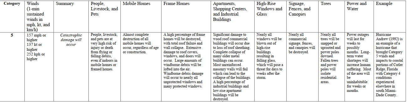
Its well documented what a strong hurricane will do. Which is why I previously wrote that I expected scouring, considering 180 mph wind.
What I find astounding is that there is anything left.
With a cat 5 hurricane, 157 mph or more), you can expect "A high percentage of framed homes will be destroyed, with total roof failure and wall collapse. Fallen trees and power poles will isolate residential areas. Power outages will last for weeks to possibly months. Most of the area will be uninhabitable for weeks or months."


Heavy cat 5, scary. The models have continually underestimated.
And it looks to hang around the Bahamas for a whole day. What will be left of the Bahamas?