High Wind Warning Thursday October 17th


yeah, for once I'm looking forward to it. long dry spell.
and I'll finally find out if they fixed my roof leak.

https://www.youtube.com/watch?v=mpoLgtJ0kPQ
All the leaves are brown (all the leaves are brown)
And the sky is grey (and the sky is grey)
I've been for a walk (I've been for a walk)
On a winter's day (on a winter's day)…


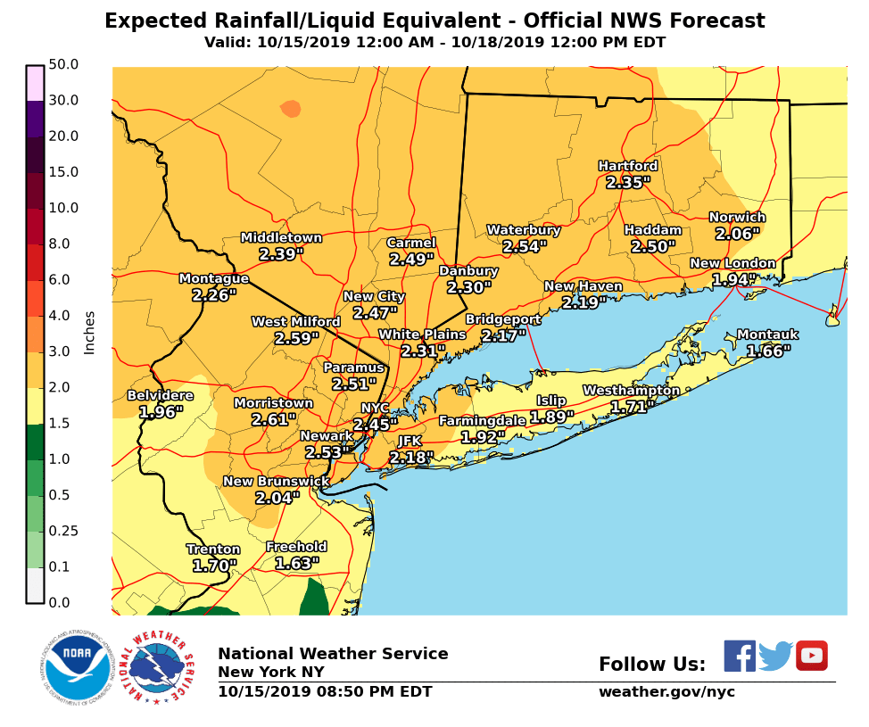
Updated forecast for tomorrow, Wednesday 10/16.
Models are in general agreement for a heavy rain storm tomorrow afternoon and evening, with rain starting as early as 2:00pm and extending past midnight. Rainfall of 2 - 3" is expected and the NWS has issued a FLASH FLOOD WATCH from 4:00pm on (see details next comment). Previous dry conditions have led to low river levels, so major flooding is not expected but roads and low-lying areas that flood regularly are likely to be impacted.
The rain will be accompanied by breezy conditions, with steady winds in the 10 - 20mph with gusts of 25 - 40mph possible.
Conditions will be significantly worse north and northeast, with more rain expected in the Hudson Valley and New England.
Flash Flood Watch
Flood Watch
National Weather Service New York NY
320 PM EDT Tue Oct 15 2019

...PERIODS OF HEAVY RAINFALL LATE WEDNESDAY AFTERNOON AND NIGHT...

NJZ002-004-006-103>108-160830-
/O.NEW.KOKX.FF.A.0008.191016T2000Z-191017T0800Z/
/00000.0.ER.000000T0000Z.000000T0000Z.000000T0000Z.OO/
Western Passaic-Eastern Passaic-Hudson-Western Bergen-
Eastern Bergen-Western Essex-Eastern Essex-Western Union-
Eastern Union-
320 PM EDT Tue Oct 15 2019

...FLASH FLOOD WATCH IN EFFECT FROM WEDNESDAY AFTERNOON THROUGH
LATE WEDNESDAY NIGHT...

The National Weather Service in Upton has issued a

* Flash Flood Watch for a portion of northeast New Jersey,
  including the following areas, Eastern Bergen, Eastern Essex,
  Eastern Passaic, Eastern Union, Hudson, Western Bergen,
  Western Essex, Western Passaic, and Western Union.

* From Wednesday afternoon through late Wednesday night

* A strong frontal system approaches Wednesday, with a rapidly
  intensifying coastal low tracking just southeast of the area
  Wednesday night. This will result in moderate to heavy rainfall
  late Wednesday afternoon and night. Much of the area will see 2
  to 3 inches of rainfall with the potential for localized bands
  of higher amounts. The heaviest rain will exit the area by
  midnight.

* Flash flooding is possible along the faster responding small
  river and streams across the watch area. Urban and poor
  drainage flooding is possible as well.

PRECAUTIONARY/PREPAREDNESS ACTIONS...

A Flash Flood Watch means that conditions may develop that lead
to flash flooding. Flash flooding is a very dangerous situation.
You should monitor later forecasts and be prepared to take action
should flash flood warnings be issued.

If you have a leaf clogged drain or curb area near you, get out there with a rake. Clear the drain of leaves. Rake a channel in the street next to the curb so water can flow more easily into the drain without clogging. I do this before a predicted heavy rain storm and it makes a lot of difference.
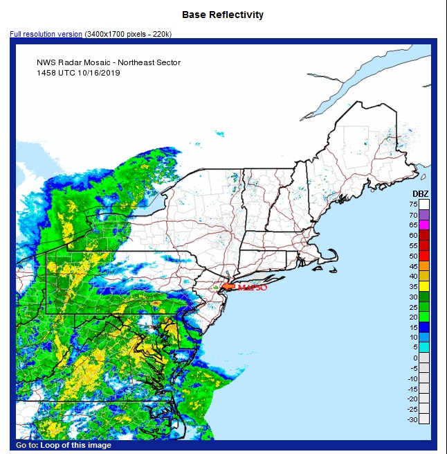
Rain, likely heavy at times, will overspread the area quickly from west to east starting around noon and becoming heavy after 2:00pm.
Heaviest rain will be during the evening rush.
Winds 15 - 25mph with gusts to 35mph.
Some thunder is possible.
A flash flood watch will be in effect this afternoon and evening for northeastern NJ.
This is WNYC's take on this evening:
Tonight: heavy rain possible, with freaky fast wind gusts and lows around 50.
Freaky fast.
Alrighty then.


not the biggest concern but I'm wondering if there will be any worthwhile fall leaf peeping in the larger area after a storm like this.
bub said:
not the biggest concern but I'm wondering if there will be any worthwhile fall leaf peeping in the larger area after a storm like this.
1) not gonna be a lot of leaves left
2) it's too late to save the peeping season, I fear


mem said:
When?
It will bomb tonight, but the areas that experience that type of rapid deepening will be to the north and east.
drummerboy said:
what's "rapid deepening"?
The pressure at the center of the cyclone will fall quickly. The cyclone will deepen.
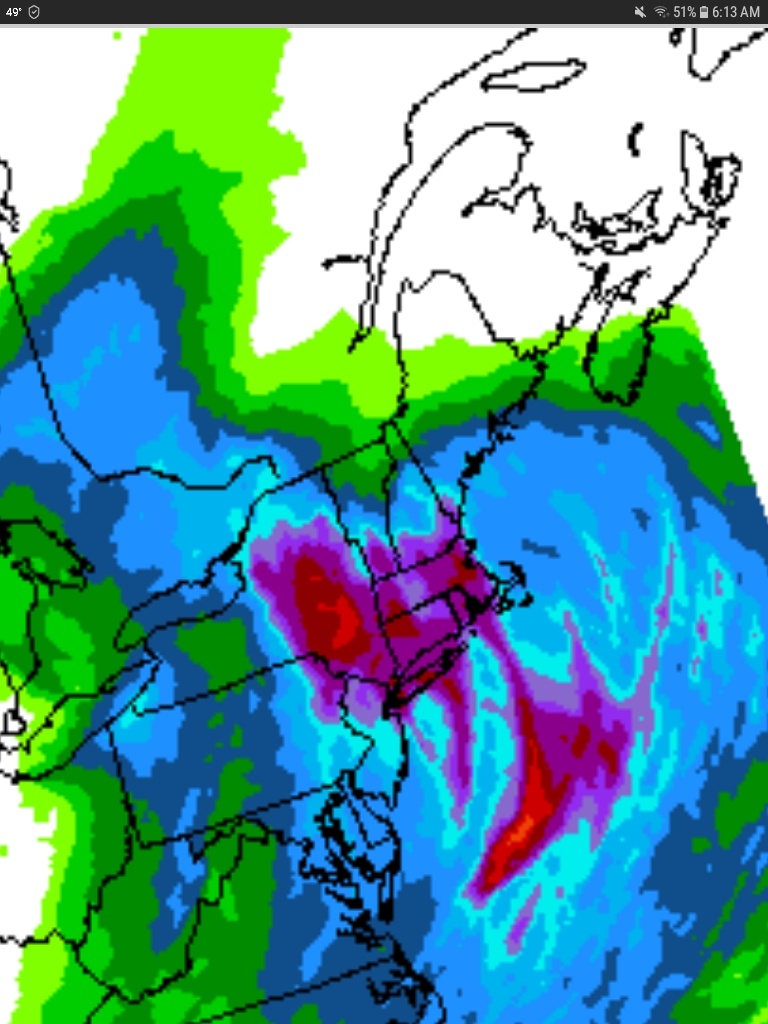
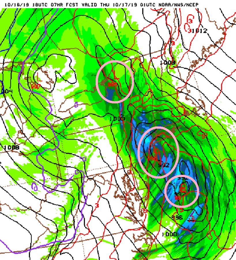
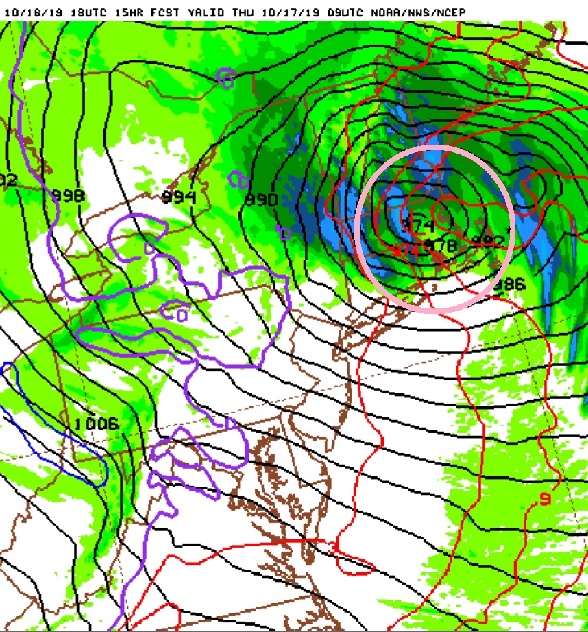
Here are two screenshots of model output showing the storm as it is now, as the three lows are phasing together, and then showing how it is likely to look later tonight after it 'bombs'. In the first picture, the lows are interacting but still have separate centers, each at about 990 mlb of pressure. In the second, they have combined and the pressure has dropped to 974 mlb. This rapid drop corresponds to a rapid intensification of the storm.
Note that, as wxnut says, the rain will be past us by then, but we still should feel some gusty winds (as forecast).
The portion of the system that will technically "bomb" is that southern area, which is sitting over the ocean. Bombs are predominantly marine events, as without the energy found within the water, it is difficult to facilitate that kind of drop in pressure. They do occur over land, but are far more infrequent and owe their rapid intensification to a largely different mechanism.

Even with the leaves out there, my street does not seem to have the big rivers gushing along the curbs.


Rentals

For Sale


Garage Sales
-

HUGE Rummage sale to benefit the Bloomfield High School Robotics Team Sale Date: Apr 27, 2024
More info

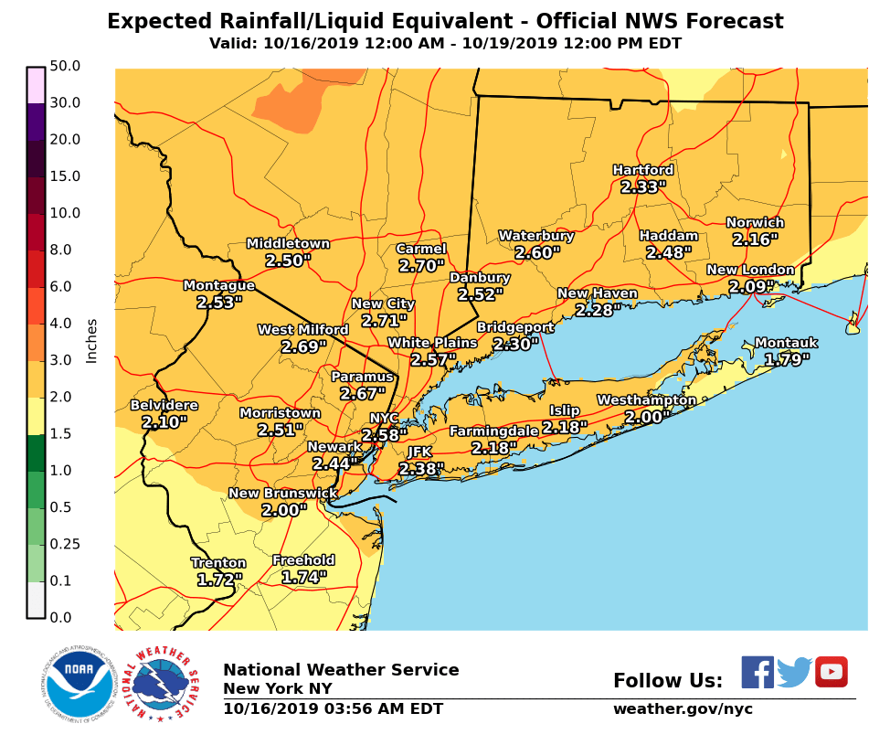
Heavy rain is likely tomorrow, Wednesday October 16th.
Two low pressure systems converge tomorrow afternoon. Rain and gusty winds spread from west to east across the area most likely after 2:00 pm and continuing into the evening, ending around midnight. 1 - 2" of rain likely with up to 3"in some areas. Winds 10 - 15 mph with gusts to 30 mph. Little flooding expected as the ground is very dry.