WINTER STORM WARNING for Monday 12/2


weather.gov is forecasting this for Sunday:
Snow likely before 10am, then rain and snow likely between 10am and 1pm,
then rain likely after 1pm. Cloudy, with a high near 43. Chance of
precipitation is 60%.


jamie said:
Any idea how things may be for a flight- Friday morning at 8am?
Should be ok, at least per the most current model runs.


There is a Hazardous Weather Advisory from the NWS for Sunday 12/1 and Monday 12/2.
A slow-moving system will track through the area Sunday and Monday.
At this time, this system should start as all snow after midnight Saturday. Light snow could become moderate for an hour or two Sunday morning before transitioning to rain.
Rain should continue for the rest of the day Sunday and through Sunday night and Monday morning. There is a possibility of some bands of moderate rain during this period, but on the whole rain should not be heavy.
Monday night snow could return at the end of the storm.
Timing is still difficult for the changeovers but the higher resolution models will come into range today and we should get a better idea by tomorrow morning.
At this time, this is NOT considered a heavy accumulation event for snow in MAPSO and in fact it is possible any accumulation Sunday will be quickly washed away. Travelers should consult local forecast for the areas they will be passing through as this storm will bring wintery conditions north and west.

What's up with Steve DeMartino these days? His forecasts are so dramatic - its it because he's branching out to cover more areas and "selling" his product harder? Certainly this seems different from the NWS.
I can't tell exactly from his map, because we (MAPSO) are right on a border between 2 different forecast areas (why is that always the case) but he seem to say we'll see either 2 -5 inches of snow, or 5 - 10?
Yikes?!

Update on the Dec 1 - 2 storm.
The forecast trend is not promising. As I said this morning, the system/storm is slow moving and long. Current timing, as of the last set of models, would be later, starting roughly at dawn Sunday, and running through most of the day and evening Monday -- about 36 hours. That said, unless some banding develops, the precipitation will not generally be hard, or even moderate. for most if not all of the period.
The issue remains where the show/rain line falls at any given time. Currently, the NAM and the Euro are running colder than the GFS, with several hours of snow or mixed precipitation Sunday morning, Monday morning, and Monday evening, and rain at all other times. This is all very subject to change. Sleet and freezing rain are possible, with sleet being much more likely.
By tomorrow evening I hope we will have a bit more clarity from the short-term models on the timing, but no promises. Updated snow and ice maps are below, but expect some change in subsequent forecasts.
finnegan said:
What's up with Steve DeMartino these days? His forecasts are so dramatic - its it because he's branching out to cover more areas and "selling" his product harder? Certainly this seems different from the NWS.
I can't tell exactly from his map, because we (MAPSO) are right on a border between 2 different forecast areas (why is that always the case) but he seem to say we'll see either 2 -5 inches of snow, or 5 - 10?
Yikes?!
Looks like he is buying the NAM forecast and disregarding the others. His forecast presupposes an almost all-snow solution, with the rain seemingly not melting the snow in the intervals. I hope he is wrong.

finnegan said:
What's up with Steve DeMartino these days? His forecasts are so dramatic - its it because he's branching out to cover more areas and "selling" his product harder? Certainly this seems different from the NWS.
I can't tell exactly from his map, because we (MAPSO) are right on a border between 2 different forecast areas (why is that always the case) but he seem to say we'll see either 2 -5 inches of snow, or 5 - 10?
Yikes?!
Steve Dimartino is a horrendous meteorologist. I wouldn’t trust him as far as I can throw him. Also a huge climate change denier, but that’s another story.

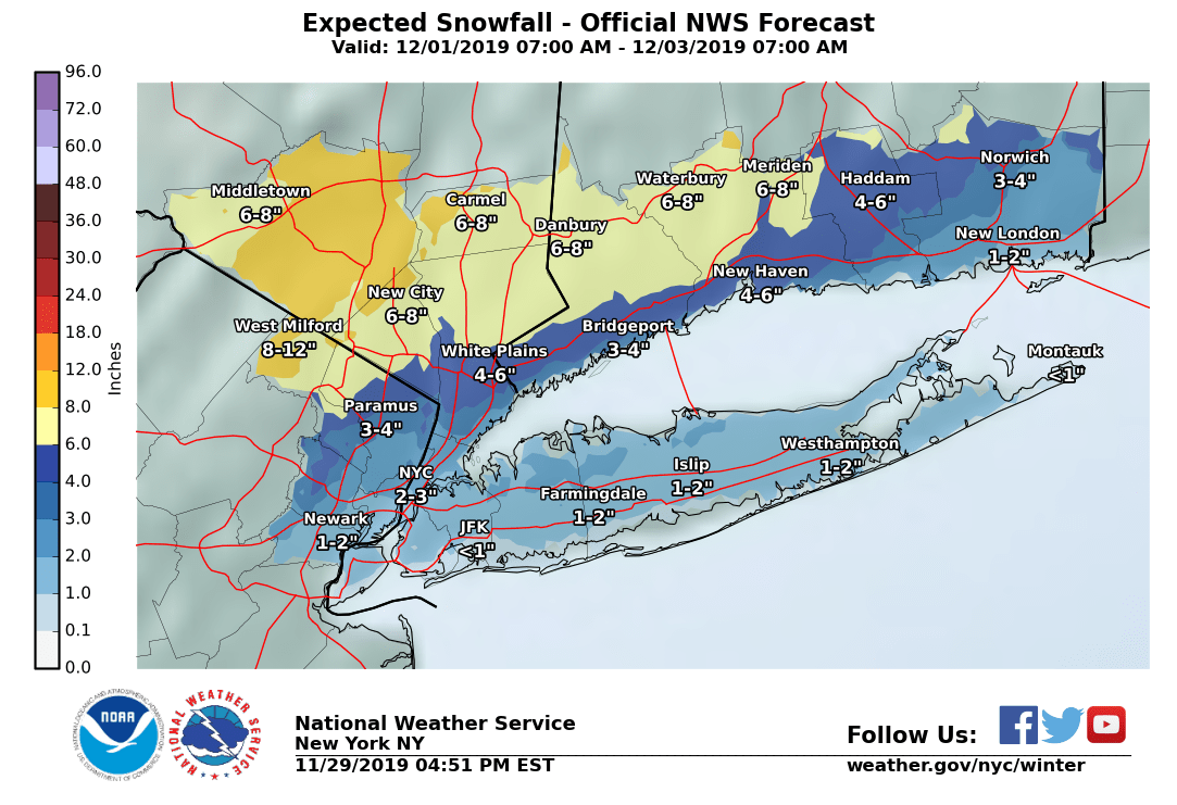
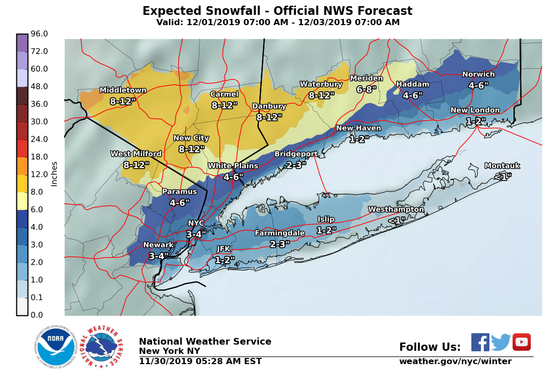
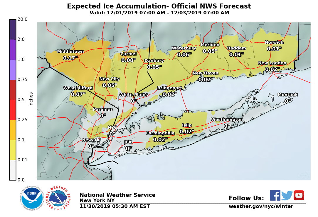
@max: The maps you posted above show snow and ice accumulation predictions for eastern Essex County (Newark) but that shaded area does not extend to western Essex County where Maplewood and SO are located. Other maps I have seen show higher accumulation predicted for western Essex County. Do the Newark figures in your maps extend to us?
joan_crystal said:
@max: The maps you posted above show snow and ice accumulation predictions for eastern Essex County (Newark) but that shaded area does not extend to western Essex County where Maplewood and SO are located. Other maps I have seen show higher accumulation predicted for western Essex County. Do the Newark figures in your maps extend to us?
Frankly at the moment Joan it's a crapshoot. This system is complex and in flux especially as to where the rain snow line sets up at any given moment.
Short post this morning, will try to go into more detail later this afternoon.
Regarding the 12/1 - 2 storm, this is a very complex system. At any given point in the 36 hours this storm will be affecting us, the location of the rain/snow line will be key to the forecast and right now it is at this time inconclusive where this will be any time after mid morning Sunday. This means that any forecast you are seeing, mine included, should show a wide range of outcomes because there is a very high level of uncertainty.
That said, there is the potential for a few inches of accumulating snow, particularly Sunday morning and Monday all day. There is also the potential for freezing rain at several points in period and a likelihood of sleet at some points in the period.
I expect Winter Weather Advisories and Watches already in place for areas north and west to be extended to our area later today by the NWS.
If you can change your Sunday travel plans to today, you may want to consider doing so.
Timing has changed, with the initial snow on Sunday morning now possibly remaining snow or mixed snow and sleet all day.
~~~~~~~~~~~~~~~~~~~~~~~~
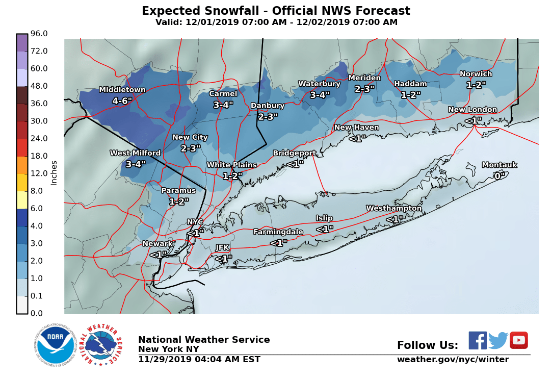
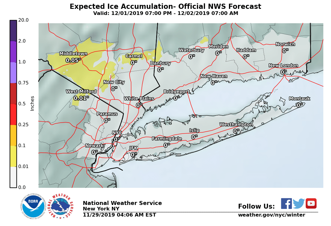
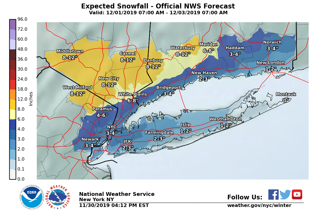
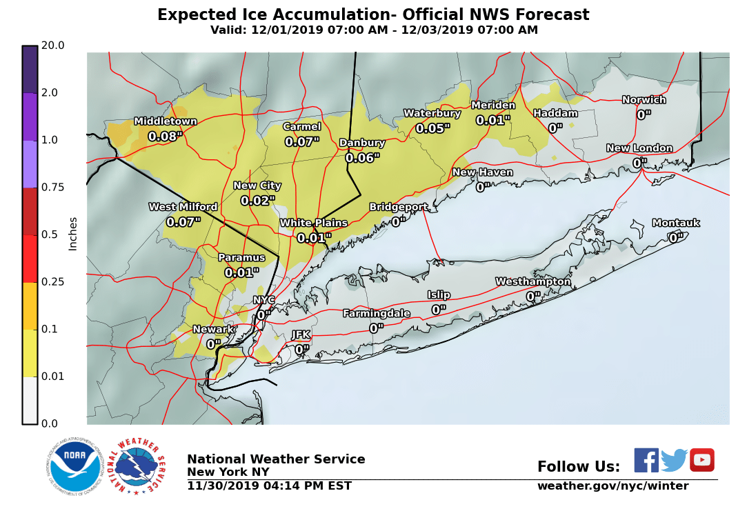
The maps below will without question look different later today, but they are decent guides for the range of thinking at the NWS right now. If anything, I would post a wider range on the snow map.
Also note that there may or may not be periods of melting during the storm if we change over to all rain at any point.
I guess not so short after all....

Time to make sure the snowblower is gassed up and starts smoothly. Maybe the generator too?
Disclaimer: the following is very subject to change, as even a small southward track in the storm would have a big impact. I’m sure I’ll jinx myself by saying this but I’m not sure I buy into the huge snow totals for this area that some forecasters are throwing around. At least not yet.
Interesting evolution to this system for sure. At the surface, a mature cyclone is translating eastward from the northern Great Plains. This system is riding along the northern fringes of a strong upper-level jet stream, and to be honest is in a bit of a strange geographic position relative to many of the storms I’ve seen before. As it moves east, it elongates as it approaches the area. Depending upon which models you trust, the storm that impacts us is either the regeneration of the eastern edge of the very baggy surface cyclone, or a new area of surface development adjacent to the Jersey coast. Either way, a relatively warm atmospheric column (due to a combination of the geometry of the approaching cyclone as well as the ambient environment — it is still early in the season) is what makes this tricky. The temperature gradient necessary to drive strong/rapid cyclone development (cyclogenesis; the development of a surface low pressure) is sort of lacking, leaving us what looks like a really messy event. In these types of situations, we’d expect to see strong funneling of cold air into the area on the back side of the surface low, helping to drive snow production. The cold air in this case isn’t exactly plentiful (maplewood to NYC is straddling the freezing line just above the surface Monday morning), so the big question here becomes, as always, where will the snow bands develop? Unfortunately, this is a nearly impossible thing to predict until it’s pretty much already happening. Odds are, for our region there will be areas that see some decent snow totals, but I’m not totally ready to commit to saying where they’ll be. For maplewood, 3 inches plus some decent icing seems possible, however any banded structures that may develop in the vicinity could wreak havoc.
TL;DR: As it stands, an early season snow storm without the necessary thermodynamics (in our immediate area) to produce widespread huge snow totals around here seems likely. Higher totals are possible if heavy snow bands develop, which is a highly small-scale process that is difficult to predict. Expect a few inches and maybe some ice, but don’t completely sleep on a few higher totals.

Not going to lie: this post, on Saturday evening, is not going to answer your most pressing questions. If you are looking for certainty, this is not your storm system.
From Sunday morning 12/1 through Monday night 12/2 the area will be affected by a winter storm. Although the models are in generally good agreement about the range size and duration of the storm, they differ between each other and from run to run on the type of precipitation we will be seeing. The farther into Monday we get, the higher the level of uncertainty, although frankly anything after Sunday morning is pretty much a game of odds right now.
With that disclaimer, at this time my best guess is that we will start off early Sunday morning with two to four hours of snow that will gradually change over to mixed snow and sleet, sleet, and then rain. Before the rain there may be an accumulation of anywhere from a coating to two inches of snow and sleet that with luck the rain will eventually remove. A bit more at higher elevations (looking at you, Newstead).
Rain and sleet will likely continue throughout the day, light to moderate, and overnight into Monday early morning.
Rain should change back through sleet to snow in the predawn hours of Monday, with a possibility of snow continuing all day, with a few inches (1"- 6") of accumulation when the snow ends overnight Monday-Tuesday. Monday's forecast is based on several models hinting (to use the NWS terminology) at a band of heavy snow developing over northern NJ and the city. Features like this band, in forecasts this volatile, this far out, are often mirages, but I want to mention it because if it materializes, it is the difference between 1 - 2 inches and 6+ inches.
Conditions are likely to be much worse north and west, with 12+" possible in northwestern PA, the Hudson Valley, and parts of Massachusetts.
If you have been playing along at home, you may have noticed that, for Sunday at least, this forecast is actually a little better than this morning's. Nonetheless, the NWS has, as expected, posted a Winter Weather Advisory for Sunday. I'll put it in the comments below.
URGENT - WINTER WEATHER MESSAGE
National Weather Service New York NY
441 PM EST Sat Nov 30 2019
Southern Fairfield-Eastern Passaic-Eastern Bergen-Western Essex-Western Union-Southern Westchester-
...WINTER WEATHER ADVISORY IN EFFECT FROM 7 AM TO 7 PM EST SUNDAY...
* WHAT...Mixed precipitation expected. Total snow accumulations of 1 to 3 inches and ice accumulations of a light glaze.
* WHERE...Portions of northeast New Jersey, southern Connecticut and southeast New York.
*
WHEN...From 7 AM to 7 PM EST Sunday. Accumulations of freezing rain will be possible in the early to late afternoon hours prior to a change over to all rain.
* IMPACTS...Plan on slippery road conditions.
* ADDITIONAL DETAILS...Potential for additional accumulating snowfall Monday afternoon into Monday night.
PRECAUTIONARY/PREPAREDNESS ACTIONS...
Slow down and use caution while traveling.
Check local Department of Transportation information services for the latest road conditions.
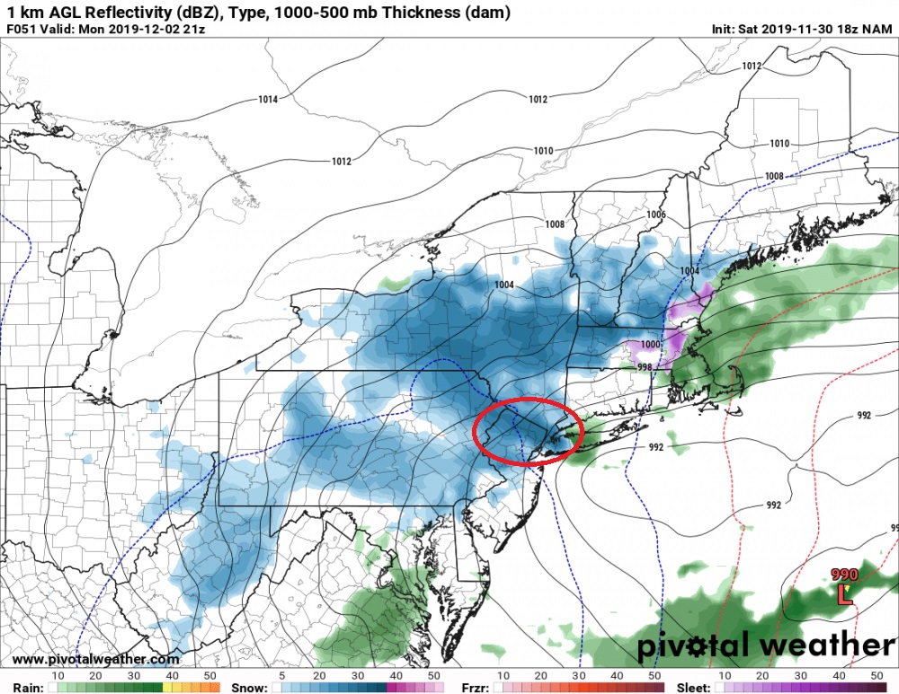
Here's a screenshot of the NAM with the band of heavy precipitation for Monday showing. Remember that this is a low-confidence forecast feature, but is shows how narrow the band is and how sharply bordered. Any movement, or if the band is a no-show, completely changes Monday's precipitation types and totals.
max_weisenfeld said:
Here's a screenshot of the NAM with the band of heavy precipitation for Monday showing. Remember that this is a low-confidence forecast feature, but is shows how narrow the band is and how sharply bordered. Any movement, or if the band is a no-show, completely changes Monday's precipitation types and totals.
Honestly wouldn’t trust this at all. The representation of those bands is more a feature of more resolution than reality.
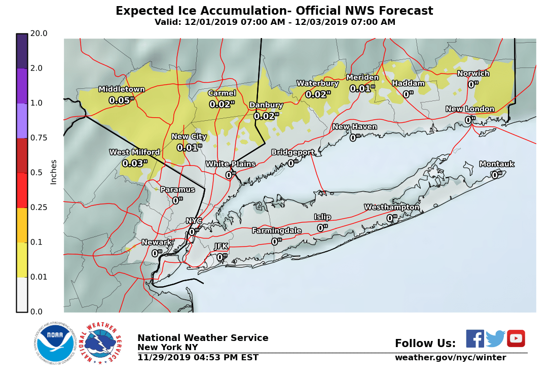
I have a question regarding the Ice Accumulation map - the numbers posted seem very very low, but now I'm wondering what is considered a significant amount of ice. e.g. Is 0.01 something to be concerned about?
My personal prediction is nobody will be happy with whatever decision the school district makes Monday morning.
They'll either cancel school and people will gripe that it wasn't that bad, or school will happen and people will complain that it wasn't a safe decision.
Either way I have to drive to Galloway on Monday a.m. Hopefully the Parkway is well-managed.

mrincredible said:
My personal prediction is nobody will be happy with whatever decision the school district makes Monday morning.
They'll either cancel school and people will gripe that it wasn't that bad, or school will happen and people will complain that it wasn't a safe decision.
Inevitably the case!

Thanks, Max! You make storms more interesting and easier to understand.
I wasn’t looking for certainty. Wanted to know if this was a Sunday, Monday, Tuesday, Weds thing. I didn’t see that info. So, looks like Sunday- Monday, right?

mrincredible said:
My personal prediction is nobody will be happy with whatever decision the school district makes Monday morning.
They'll either cancel school and people will gripe that it wasn't that bad, or school will happen and people will complain that it wasn't a safe decision.
Either way I have to drive to Galloway on Monday a.m. Hopefully the Parkway is well-managed.
100%
But the people who complain if school is canceled and the weather is a non-event should remember -- people went ballistic last November when the schools weren't canceled after a prediction of minor precipitation was followed by a complete transportation cluster when more snow than expected arrived.
Rentals

Sponsored Business


Promote your business here - Businesses get highlighted throughout the site and you can add a deal.

Wednesday 11/27 showers possible, not too heavy and all rain if they come, but these showers are part of a larger system that may still disrupt air travel with their knock-on effects.
Next weekend, although still too far out to have any certainty, there is possibly a mix of rain and snow. This one will be one of those last-minute calls we so love this time of year. More details Friday.