Messy Day Today, Wednesday Feb 7th, with some snow, sleet, and rain.

weather.gov:
Tuesday Night
A 20 percent chance of snow after 3am. Increasing clouds, with a low around 26. West wind around 6 mph becoming light and variable.
Wednesday
Snow before 11am, then snow, freezing rain, and sleet between 11am and noon, then rain after noon. High near 42. Wind chill values between 20 and 30. East wind around 7 mph becoming south in the afternoon. Chance of precipitation is 90%. Little or no ice accumulation expected. New snow and sleet accumulation of 1 to 3 inches possible.
Wednesday Night
Rain, possibly mixing with snow after midnight, then gradually ending. Low around 27. Southwest wind 8 to 11 mph becoming northwest after midnight. Chance of precipitation is 80%. Little or no snow accumulation expected.

Any timing yet on the Wednesday morning start? Need to be at JFK by 7:30 and wondering if it would be better to get a hotel room nearby the night before (although I dislike most of the lodgings there).

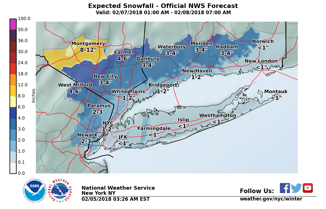
Wednesday's forecast remains on track: probable snow in the morning, becoming moderate around 6-7:00 am and continuing through the morning commute; changing over to rain midday with a period of sleet at changeover. Then rain likely until evening. After the rain stops, overnight hard freeze possible. The NWS does not expect the snow to reach watch levels here, and it is likely that most will be washed away by the evening rush.
Be alert for icy patches during the changeover Wednesday and also Thursday morning.


Going to LA for a week in March! I have earned a break from the East Coast!
Winter Weather Advisory
URGENT - WINTER WEATHER MESSAGE
National Weather Service New York NY
333 PM EST Tue Feb 6 2018
CTZ005>008-NJZ004-103-105-107-NYZ069-070-070445-
/O.NEW.KOKX.WW.Y.0007.180207T1100Z-180207T2200Z/
Northern Fairfield-Northern New Haven-Northern Middlesex-
Northern New London-Eastern Passaic-Western Bergen-Western Essex-
Western Union-Rockland-Northern Westchester-
333 PM EST Tue Feb 6 2018
...WINTER WEATHER ADVISORY IN EFFECT FROM 6 AM TO 5 PM EST
WEDNESDAY...
* WHAT...Mixed precipitation expected. Total snow accumulations
of 1 to 3 inches, with localized amounts up to 5 inches, and
ice accumulations of up to one tenth of an inch are expected.
* WHERE...Portions of northeast New Jersey, southern Connecticut
and southeast New York.
* WHEN...From 6 AM to 5 PM EST Wednesday.
* ADDITIONAL DETAILS...The ice will result in difficult travel
conditions, including during the morning commute on Wednesday.
Be prepared for reduced visibilities at times.
PRECAUTIONARY/PREPAREDNESS ACTIONS...
A Winter Weather Advisory means that periods of snow, sleet or
freezing rain will cause travel difficulties. Be prepared for
slippery roads and limited visibilities, and use caution while
driving. Check local Department of Transportation information
services for the latest road conditions.
&&
The forecast for tomorrow is still on track, with snow starting just before the morning commute and changing over to rain, possibly passing through a period of sleet, in the early afternoon.
Total snow of 1 - 2"
Do not expect ice accumulation, however roads in the morning may be slick, and freezing temperatures overnight Wed into Thurs may leave frozen puddles or black ice in places Thursday morning.
The NWS has issued an advisory. I expect us to be on the low end of the accumulation projection, and likely most will wash away with the rain, although the models have trended to a slower solution with less rain at the back end over the past few runs.
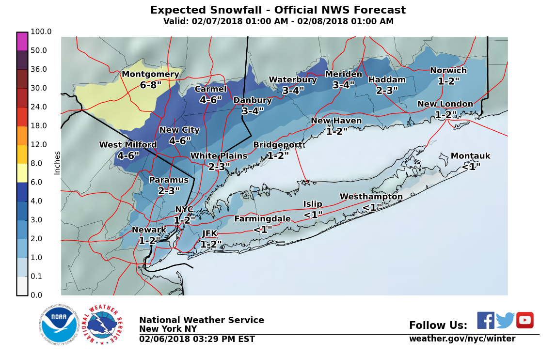
&& Weather forecast continues on track this morning. Snow will overspread the area in the next hour or so. By mid-morning, will begin mixing with sleet and perhaps freezing rain, changing over to all rain by mid-day.
Rain ends this evening. No significant accumulation of snow or ice expected.
Overnight temps drop and wet areas could freeze. Be alert for slippery roads this morning and Thursday morning.


husband said the roads were terrible getting to Caldwell, anyone have anything to report on the Garden State? thanks!

To shovel or not to shovel (now), that is the question. Will be in high 30s and raining later. Do I shovel now to minimize chance of an icy rain-over-snow combo or just let the temperature and rain do the work later.

I'm going to wait and see what happens. Forecasts I have been following say what is on the ground, which isn't much, will be washed away by this evening. If not, I will deal with what's left in the morning.

joan_crystal said:
I'm going to wait and see what happens. Forecasts I have been following say what is on the ground, which isn't much, will be washed away by this evening. If not, I will deal with what's left in the morning.
This is my plan also.

sac said:
joan_crystal said:
I'm going to wait and see what happens. Forecasts I have been following say what is on the ground, which isn't much, will be washed away by this evening. If not, I will deal with what's left in the morning.
This is my plan also.
Me three...

Many school districts west of SOMA closed today - including mine. Kids were delighted. Me? Not so much.

I shoveled. It’s slippery now, but I’m not going to salt until I see what happens...
There is likely to be a window between when the rain ends this evening and when the temperature starts dropping, probably from around 8:00 to 11:00 or midnight. If there is anything still on the ground at that point I personally am going to clear and salt it.
Temperatures in the morning will be well below freezing, and are not likely to rise above freezing until Friday afternoon, so whatever remains is likely to freeze and become difficult to remove.
I just got back from shoveling what amounted to chunks ofwater from my front entrance and sidewalks/cutouts. I couldn't get all of in the dark it but hopefully the dry period plus sun tomorrow will get the rest. Most of my neighbors have yet to clear anything.
It’s going to be an icy mess tomorrow. Any possibility of calling a snow day? Not that I'm wishing for it just wondering if I should prepare for the possibility.
Rentals

For Sale


Garage Sales
-

Multi Family Garage Sale Sale Date: Apr 20, 2024
More info


Wednesday is shaping up to be a real mess. It is possible that snow in the morning changes through sleet to rain, then in the evening transitions back through to sleet, then the puddles freeze overnight.
Projecting snow depth at any point in the day, and whether any will remain after the precipitation stops will be very difficult unless there is a dramtic change in the temperature profile, which is unlikely, so be prepared but be aware too of the direction temps are moving over the course of the day.
Forecast at this moment has the snow starting in the morning and ending as sleet in the evening, but this, too, could change.