Rain likely Monday and Tuesday, March 13 - 14


The Ledger has been screaming about a nor’easter, so I am happy to read your downgrade of that assessment, and I thank you on behalf of all of us for the time you spend keeping us in the know.

Heynj said:
The Ledger has been screaming about a nor’easter, so I am happy to read your downgrade of that assessment, and I thank you on behalf of all of us for the time you spend keeping us in the know.
It is a nor'easter. We are not by any means getting the worst of it.

Sunday Afternoon March 12 update
TLDR: Monday through Tuesday, likely rain, mixing with snow, followed by windy conditions Tuesday and Wednesday. North and East of the MAPSO area, there is significant potential for heavy, disruptive snowfall.
More details: Rain possible early Monday morning, possibly mixed with snow. No accumulation. Monday morning, steady rain likely. Rain likely continues all day Monday and through Monday night into Tuesday. Rain likely Tuesday during the day, not as heavy, possibly mixing with snow. Little or no accumulation, ending late Tuesday afternoon or evening. Wind likely to pick up Tuesday morning, 20 - 25 mph with 35 - 40 mph gusts, continuing through Wednesday night.
Deep dive:This has been a wild day for model watching. While there is still significant disagreement between the models, there is growing confidence about the above forecast. That is, my confidence is growing, the NWS is holding firm (when in doubt, listen to the smartest people in the room), and the weenies on the internet weather boards are mostly conceding.
What's going on with the models? you might ask.
Well, there are different types of models that feature different aspects of the atmosphere. In this case, there is a disagreement between the global models (the GFS, the Euro, and others), and specifically an American mesoscale model called the NAM. Mesoscale models look at smaller features in the atmosphere than global models do. The global models look at, well, the whole globe. They also look out farther in time, and are more accurate in longer (3 - 5 day) windows than mesoscale models.
All the models are in agreement that there will be a storm, a nor'easter.
Currently, there is a powerful low pressure area over Georgia that will work its way up the coast and pass off the mid Atlantic shore before stalling over Cape Cod. This is a pretty standard Miller A nor'easter (look it up on Wikipedia, this post is long enough already). The rain/snow line sets up in northern Bergen County, and the snow really gets serious in the upper Hudson Valley and Berkshires.
The NAM, which is still somewhat outside its accuracy window, though, is showing both a wetter (twice as much precipitation) and colder solution for our area.
==> This is a very unlikely solution and is NOT supported by the other models!
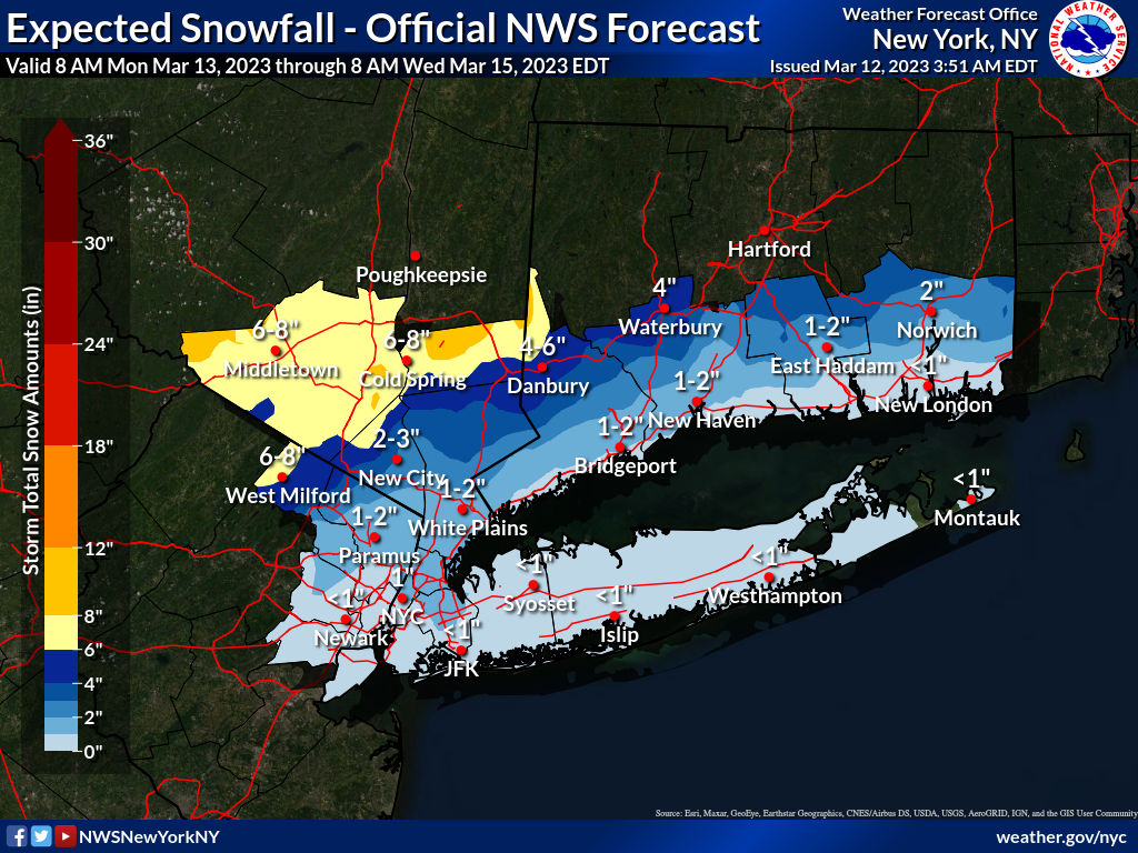
So, barring a significant freak out by the globals, I expect the NAM to shift its projections over the next 18 hours to come much more in line with the GFS and Euro. I also forecast a few more hours of internet frenzy as people look at unrealistic snowmaps and post clickbait stories. Also, this time of year the auto-generated snowmaps that the models put out can be wildly inaccurate, as many of them do not accurately account for the temperature and the effect of mixed snow and rain, so they overstate the actual accumulations. imho. So I'm posting a snowmap made by the very smart people at the NWS, that shows us getting less than 1" of snow.


I’m going with the 1 to 3 inches of heavy snow, seems like that’s the pattern for this winter.
Monday morning, March 13 update.
Forecast on track for this nor'easter to be a mostly rain and wind event here in MAPSO.
Light mixed snow and rain has started this morning, changing over to a steady rain during the day today. Tonight, moderate rain, heavy at times. Tuesday, rain, tapering off in the afternoon, may mix with snow. No significant accumulation expected. Wind picks up Tuesday morning, 20 - 25mph with gusts 40 - 45. Wind continues with chance of light rain or a bit of snow mixing on Wednesday.
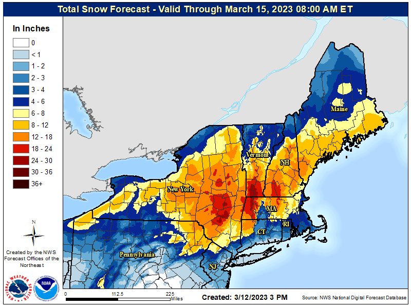
This is likely to be a major snowstorm elsewhere in the region, with 4 - 6" in Western Passaic County, and up to a foot in the Hudson Valley and New England.
Tuesday morning March 14th update
Forecast on track as rain returns this morning, possibly mixing with snow midday. Little snow accumulation likely, perhaps an inch or so on the grass. Winds likely to pick up later this morning, with steady 20 - 25mph and gusts into the low 40mph range. Precipitation ends this evening, winds continue through the day Wednesday.


Thank you so much Max ! My co-workers always ask me what your forecast is for days like today. I tell them you're the best !

Sponsored Business


Promote your business here - Businesses get highlighted throughout the site and you can add a deal.


Sunday, March 12, 2023
A complex system with multiple lows will be passing through the area between tonight and Tuesday, bringing mostly rain.
Slight chance of rain tonight. Light rain possibly developing Monday during the day becomes more likely in the afternoon and evening. Rain likely Monday night, moderate with a possibility of heavier rain at times. Tuesday morning precipitation could be mixed rain and snow, tapering off during the morning.
Little or no snow accumulation expected here.