Severe Drought Extends to Central New Jersey


The good news is, I suppose, that as warm and dry conditions are expected to continue long-term, chances of a snowy winter are reduced.

Thanks Max. Maybe it is time to turn off the automatic lawn sprinklers folks.


This is from the NWS:
DROUGHT INFORMATION STATEMENT
NATIONAL WEATHER SERVICE NEW YORK NY
...SEVERE DROUGHT CONDITIONS ARE IN EFFECT ACROSS LONG ISLAND,
SOUTHERN CONNECTICUT, QUEENS, BRONX, RICHMOND, WESTCHESTER, PUTNAM,
ORANGE AND ROCKLAND COUNTIES IN NY AND ACROSS NORTHERN NJ...
SYNOPSIS...
A PERSISTENT, DRY WEATHER PATTERN THAT BEGAN THIS SPRING AND SUMMER
HAS CONTINUED THROUGH THE MONTH OF OCTOBER. RAINFALL DEFICITS OF TWO
TO THREE INCHES CONTINUED ACROSS THE SEVERE DROUGHT AREA DURING THE
LAST MONTH. RAINFALL DEFICITS SINCE JANUARY 1ST RANGE FROM EIGHT TO
TWELVE INCHES.
ALTHOUGH RECENT RAINS HAVE HELPED TO IMPROVE DROUGHT CONDITIONS, A
SUSTAINED PERIOD OF NEAR NORMAL PRECIPITATION WILL BE NECESSARY TO
RETURN TO NORMAL LEVELS OF WATER AVAILABILITY.
THE OCTOBER 27TH RELEASE OF THE U.S. DROUGHT MONITOR SHOWED SEVERE
DROUGHT CONDITIONS EXPANDING THROUGH MOST OF THE LOCAL HYDROLOGIC
SERVICE AREA.
THE DROUGHT MONITOR IS UPDATED WEEKLY WITH THE LATEST CONDITIONS
AVAILABLE ONLINE.
SUMMARY OF IMPACTS...
THE LATEST NEW YORK...NEW JERSEY AND CONNECTICUT STATE DROUGHT
MANAGEMENT TASK FORCE CONTINUED SEVERE DROUGHT CONDITIONS ACROSS
MOST OF THE HYDROLOGIC SERVICE AREA.
SOIL MOISTURE CONDITIONS...
THE LATEST CROP MOISTURE INDEX ISSUED BY THE CLIMATE PREDICTION
CENTER INDICATED ABNORMALLY DRY SOIL MOISTURE ACROSS THE AREAS UNDER
THE SEVERE DROUGHT CONDITIONS.
GROUNDWATER CONDITIONS...
THE USGS GROUND WATER LEVEL NETWORK SHOWS THAT NUMEROUS WELLS ACROSS
AREAS UNDER THE SEVERE DROUGHT CONDITIONS ARE RUNNING BELOW NORMAL
TO MUCH BELOW NORMAL. IT TYPICALLY TAKES A LONG TIME ON THE ORDER OF
WEEKS FOR GROUND WATER TABLES TO RESPOND TO RAINFALL...OR TO THE
LACK OF RAINFALL.
RIVER AND STREAMFLOW CONDITIONS...
FLOWS ON STREAMS ACROSS AREAS UNDER THE SEVERE DROUGHT ARE MUCH
BELOW NORMAL.

max_weisenfeld said:
The good news is, I suppose, that as warm and dry conditions are expected to continue long-term, chances of a snowy winter are reduced.
Here's hoping for a really snowy winter and lots of spring showers.
Sponsored Business


Promote your business here - Businesses get highlighted throughout the site and you can add a deal.
Rentals
-
Huge Brand New construction Apartment in 2 family home with 4 bedrooms 3 bathrooms

4 Bd | 3Full Ba
$4,500

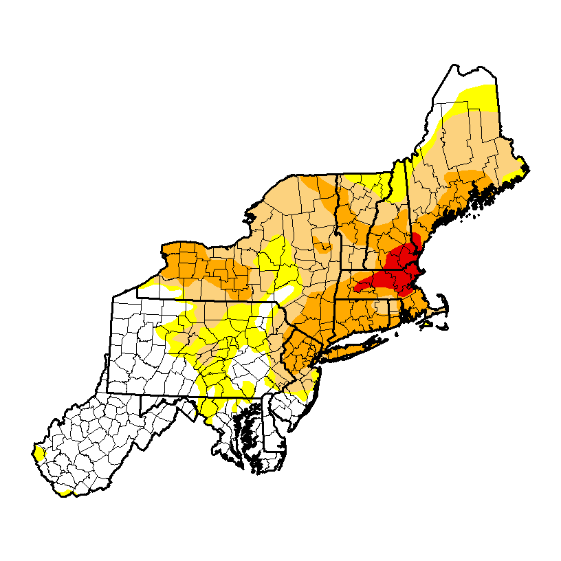
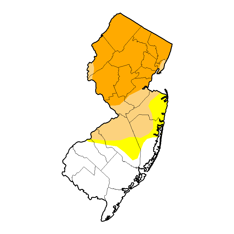
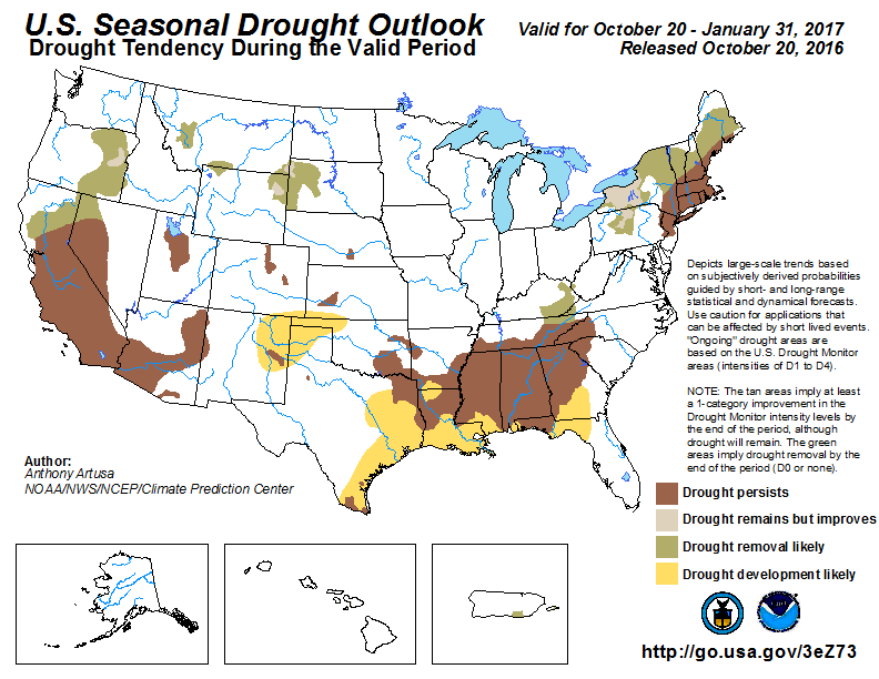
The area of Stage D2 Severe Drought now covers the entire northern half of New Jersey, as can be seen in the first two images below. The third image is last week's map, so you can see that the dry week tipped us into a new category -- we had been in stage D1 for most of the year. Yellow is stage D0 -- abnormally dry. Light Tan is D1 -- moderate drought. Dark tan is D2 -- severe drought. Red is buy a camel drought.
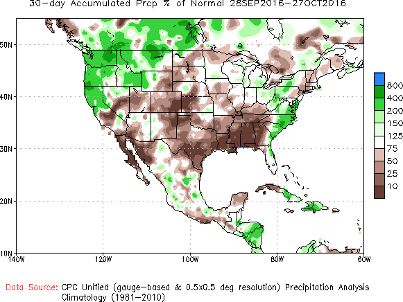
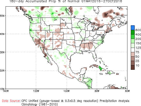
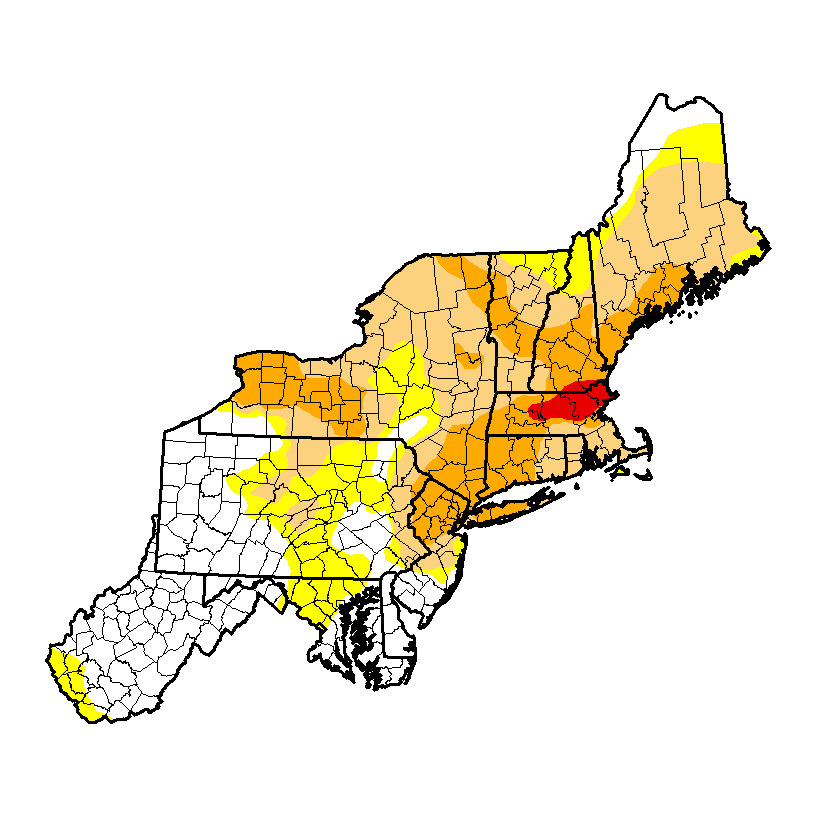
The next images show the percent of normal rainfall over the last 30 and 180 days. The 30 day image shows us with only 25% of normal, and the 180 day image has us at 50%. So the long-term shortfall has become more severe in the last month.