ICE ON ROADS NOW: Winter Weather Advisory remains in effect until 2:00 pm today

Wind Advisory
URGENT - WEATHER MESSAGE
NATIONAL WEATHER SERVICE NEW YORK NY
320 PM EST WED DEC 14 2016
...HIGH WINDS POSSIBLE...
320 PM EST WED DEC 14 2016
...WIND ADVISORY IN EFFECT FROM 9 AM TO 6 PM EST THURSDAY...
...HIGH WIND WATCH IN EFFECT FROM THURSDAY EVENING THROUGH LATE
THURSDAY NIGHT...
THE NATIONAL WEATHER SERVICE IN UPTON HAS ISSUED A WIND
ADVISORY...WHICH IS IN EFFECT FROM 9 AM TO 6 PM EST THURSDAY. A
HIGH WIND WATCH HAS ALSO BEEN ISSUED. THIS HIGH WIND WATCH IS IN
EFFECT FROM THURSDAY EVENING THROUGH LATE THURSDAY NIGHT.
* WINDS...NORTHWEST 20 TO 35 MPH WITH GUSTS UP TO 50 MPH DURING
THE DAY, AND 60 MPH AT NIGHT.
* TIMING...HIGHEST WIND POTENTIAL THURSDAY NIGHT.
* IMPACTS...POSSIBLE DAMAGING WINDS MAY BLOW DOWN TREES AND POWER
LINES. WIDESPREAD POWER OUTAGES ARE POSSIBLE. TRAVEL WILL BE
DIFFICULT...ESPECIALLY FOR HIGH PROFILE VEHICLES.
PRECAUTIONARY/PREPAREDNESS ACTIONS...
A WIND ADVISORY IS ISSUED WHEN SUSTAINED WINDS OF 31 TO 39 MPH...
OR GUSTS OF 46 TO 57 MPH...ARE EXPECTED OR OCCURRING. WINDS THIS
STRONG CAN MAKE DRIVING DIFFICULT...ESPECIALLY FOR HIGH PROFILE
VEHICLES. USE EXTRA CAUTION.
A HIGH WIND WATCH MEANS THERE IS THE POTENTIAL FOR A HAZARDOUS
HIGH WIND EVENT. SUSTAINED WINDS OF AT LEAST 40 MPH...OR GUSTS OF
58 MPH OR STRONGER MAY OCCUR. CONTINUE TO MONITOR THE LATEST
FORECASTS.
&&
~~~~~~~~~~~~~~~~~~~~~~~~~~~~~~~~~~~~~~~~~~~~~High Wind Watch
URGENT - WEATHER MESSAGE
NATIONAL WEATHER SERVICE NEW YORK NY
320 PM EST WED DEC 14 2016
...HIGH WINDS POSSIBLE...
...WIND ADVISORY IN EFFECT FROM 9 AM TO 6 PM EST THURSDAY...
...HIGH WIND WATCH IN EFFECT FROM THURSDAY EVENING THROUGH LATE
THURSDAY NIGHT...
THE NATIONAL WEATHER SERVICE IN UPTON HAS ISSUED A WIND
ADVISORY...WHICH IS IN EFFECT FROM 9 AM TO 6 PM EST THURSDAY. A
HIGH WIND WATCH HAS ALSO BEEN ISSUED. THIS HIGH WIND WATCH IS IN
EFFECT FROM THURSDAY EVENING THROUGH LATE THURSDAY NIGHT.
* WINDS...NORTHWEST 20 TO 35 MPH WITH GUSTS UP TO 50 MPH DURING
THE DAY, AND 60 MPH AT NIGHT.
* TIMING...HIGHEST WIND POTENTIAL THURSDAY NIGHT.
* IMPACTS...POSSIBLE DAMAGING WINDS MAY BLOW DOWN TREES AND POWER
LINES. WIDESPREAD POWER OUTAGES ARE POSSIBLE. TRAVEL WILL BE
DIFFICULT...ESPECIALLY FOR HIGH PROFILE VEHICLES.
PRECAUTIONARY/PREPAREDNESS ACTIONS...
A WIND ADVISORY IS ISSUED WHEN SUSTAINED WINDS OF 31 TO 39 MPH...
OR GUSTS OF 46 TO 57 MPH...ARE EXPECTED OR OCCURRING. WINDS THIS
STRONG CAN MAKE DRIVING DIFFICULT...ESPECIALLY FOR HIGH PROFILE
VEHICLES. USE EXTRA CAUTION.
A HIGH WIND WATCH MEANS THERE IS THE POTENTIAL FOR A HAZARDOUS
HIGH WIND EVENT. SUSTAINED WINDS OF AT LEAST 40 MPH...OR GUSTS OF
58 MPH OR STRONGER MAY OCCUR. CONTINUE TO MONITOR THE LATEST
FORECASTS.


Thanks Max. Even though I really don't like wind. Or cold. At least you help me feel prepared.
Question: what is the thinking about wunderground.com? I love their graph with temp/pressure/chance of precipitation/wind speed.
But from the couple of times I watched the graphs to gauge upcoming weather in the next few hours, the wind and precipitation predictions seemed to be wayyy off. E.g, the day we got some snow, it never seemed to show any % chance of snow. Another time it was about 6 hours off in predicting when the winds were going to pick up.
Am I reading it wrong? Is it not really giving me a forecast for "Maplewood, NJ"? Is it just not considered accurate at the level of detail I'm looking for (maybe it doesn't update the prediction based on real-time conditions)? And why does the predicted pressure, and actual pressure seem so far off so often (It seems to always show a big jump in the black line at the current time)?
Right now, the wunderground's predictions for tomorrow's winds are that they will peak around 1pm with speeds around 23mph. From the forecast above, the NWS is predicting the strongest winds after 6pm. (Or is it possible to have a decrease in speed of 'wind', but increase in speed of 'gusts'?). Do they use different models?
I'm mostly confused about when to be prepared to be more afraid of the wind tomorrow... daytime or nighttime?

Oh, joy!
max_weisenfeld said:
Wind Advisory
URGENT - WEATHER MESSAGE
NATIONAL WEATHER SERVICE NEW YORK NY
320 PM EST WED DEC 14 2016
...HIGH WINDS POSSIBLE...
320 PM EST WED DEC 14 2016
...WIND ADVISORY IN EFFECT FROM 9 AM TO 6 PM EST THURSDAY...
...HIGH WIND WATCH IN EFFECT FROM THURSDAY EVENING THROUGH LATE
THURSDAY NIGHT...
THE NATIONAL WEATHER SERVICE IN UPTON HAS ISSUED A WIND
ADVISORY...WHICH IS IN EFFECT FROM 9 AM TO 6 PM EST THURSDAY. A
HIGH WIND WATCH HAS ALSO BEEN ISSUED. THIS HIGH WIND WATCH IS IN
EFFECT FROM THURSDAY EVENING THROUGH LATE THURSDAY NIGHT.
* WINDS...NORTHWEST 20 TO 35 MPH WITH GUSTS UP TO 50 MPH DURING
THE DAY, AND 60 MPH AT NIGHT.
* TIMING...HIGHEST WIND POTENTIAL THURSDAY NIGHT.
* IMPACTS...POSSIBLE DAMAGING WINDS MAY BLOW DOWN TREES AND POWER
LINES. WIDESPREAD POWER OUTAGES ARE POSSIBLE. TRAVEL WILL BE
DIFFICULT...ESPECIALLY FOR HIGH PROFILE VEHICLES.
PRECAUTIONARY/PREPAREDNESS ACTIONS...
A WIND ADVISORY IS ISSUED WHEN SUSTAINED WINDS OF 31 TO 39 MPH...
OR GUSTS OF 46 TO 57 MPH...ARE EXPECTED OR OCCURRING. WINDS THIS
STRONG CAN MAKE DRIVING DIFFICULT...ESPECIALLY FOR HIGH PROFILE
VEHICLES. USE EXTRA CAUTION.
A HIGH WIND WATCH MEANS THERE IS THE POTENTIAL FOR A HAZARDOUS
HIGH WIND EVENT. SUSTAINED WINDS OF AT LEAST 40 MPH...OR GUSTS OF
58 MPH OR STRONGER MAY OCCUR. CONTINUE TO MONITOR THE LATEST
FORECASTS.
&&
~~~~~~~~~~~~~~~~~~~~~~~~~~~~~~~~~~~~~~~~~~~~~
High Wind Watch
URGENT - WEATHER MESSAGE
NATIONAL WEATHER SERVICE NEW YORK NY
320 PM EST WED DEC 14 2016
...HIGH WINDS POSSIBLE...
...WIND ADVISORY IN EFFECT FROM 9 AM TO 6 PM EST THURSDAY...
...HIGH WIND WATCH IN EFFECT FROM THURSDAY EVENING THROUGH LATE
THURSDAY NIGHT...
THE NATIONAL WEATHER SERVICE IN UPTON HAS ISSUED A WIND
ADVISORY...WHICH IS IN EFFECT FROM 9 AM TO 6 PM EST THURSDAY. A
HIGH WIND WATCH HAS ALSO BEEN ISSUED. THIS HIGH WIND WATCH IS IN
EFFECT FROM THURSDAY EVENING THROUGH LATE THURSDAY NIGHT.
* WINDS...NORTHWEST 20 TO 35 MPH WITH GUSTS UP TO 50 MPH DURING
THE DAY, AND 60 MPH AT NIGHT.
* TIMING...HIGHEST WIND POTENTIAL THURSDAY NIGHT.
* IMPACTS...POSSIBLE DAMAGING WINDS MAY BLOW DOWN TREES AND POWER
LINES. WIDESPREAD POWER OUTAGES ARE POSSIBLE. TRAVEL WILL BE
DIFFICULT...ESPECIALLY FOR HIGH PROFILE VEHICLES.
PRECAUTIONARY/PREPAREDNESS ACTIONS...
A WIND ADVISORY IS ISSUED WHEN SUSTAINED WINDS OF 31 TO 39 MPH...
OR GUSTS OF 46 TO 57 MPH...ARE EXPECTED OR OCCURRING. WINDS THIS
STRONG CAN MAKE DRIVING DIFFICULT...ESPECIALLY FOR HIGH PROFILE
VEHICLES. USE EXTRA CAUTION.
A HIGH WIND WATCH MEANS THERE IS THE POTENTIAL FOR A HAZARDOUS
HIGH WIND EVENT. SUSTAINED WINDS OF AT LEAST 40 MPH...OR GUSTS OF
58 MPH OR STRONGER MAY OCCUR. CONTINUE TO MONITOR THE LATEST
FORECASTS.
I thought NWS was doing away with the all cap thing...

sprout said:
Thanks Max. Even though I really don't like wind. Or cold. At least you help me feel prepared.
Question: what is the thinking about wunderground.com? I love their graph with temp/pressure/chance of precipitation/wind speed.
But from the couple of times I watched the graphs to gauge upcoming weather in the next few hours, the wind and precipitation predictions seemed to be wayyy off. E.g, the day we got some snow, it never seemed to show any % chance of snow. Another time it was about 6 hours off in predicting when the winds were going to pick up.
Am I reading it wrong? Is it not really giving me a forecast for "Maplewood, NJ"? Is it just not considered accurate at the level of detail I'm looking for (maybe it doesn't update the prediction based on real-time conditions)? And why does the predicted pressure, and actual pressure seem so far off so often (It seems to always show a big jump in the black line at the current time)?
Right now, the wunderground's predictions for tomorrow's winds are that they will peak around 1pm with speeds around 23mph. From the forecast above, the NWS is predicting the strongest winds after 6pm. (Or is it possible to have a decrease in speed of 'wind', but increase in speed of 'gusts'?). Do they use different models?
I'm mostly confused about when to be prepared to be more afraid of the wind tomorrow... daytime or nighttime?
I loved wunderground's wundermap for radar, but after the buyout they mucked it up and it still has not regained all the functionality it had. I do not use the rest of their tools. All the data come from the NWS, so I go to the source. The NWS version of the graphs is here: http://forecast.weather.gov/MapClick.php?lat=40.7331&lon=-74.2719&unit=0&lg=english&FcstType=graphical It seems to show the wind the way they are forecasting it.
marylago said:
A HIGH WIND WATCH MEANS THERE IS THE POTENTIAL FOR A HAZARDOUS
HIGH WIND EVENT. SUSTAINED WINDS OF AT LEAST 40 MPH...OR GUSTS OF
58 MPH OR STRONGER MAY OCCUR. CONTINUE TO MONITOR THE LATEST
FORECASTS.
I thought NWS was doing away with the all cap thing...
They got rid of it in the forecast discusssion and some of the analysis products, but I guess they still think watches and warnings need to be at top volume. ☺

The high wind watch for this evening has been upgraded to a High Wind Warning:
High Wind Warning
URGENT - WEATHER MESSAGE
NATIONAL WEATHER SERVICE NEW YORK NY
352 AM EST THU DEC 15 2016
...STRONG WINDS TODAY AND TONIGHT...
CTZ005>012-NJZ002-004-006-103>108-NYZ067>075-078>081-176>179-
152300-
/O.UPG.KOKX.HW.A.0002.161215T2300Z-161216T1100Z/
/O.NEW.KOKX.HW.W.0002.161215T2300Z-161216T1100Z/
/O.CON.KOKX.WI.Y.0008.161215T1400Z-161215T2300Z/
NORTHERN FAIRFIELD-NORTHERN NEW HAVEN-NORTHERN MIDDLESEX-
NORTHERN NEW LONDON-SOUTHERN FAIRFIELD-SOUTHERN NEW HAVEN-
SOUTHERN MIDDLESEX-SOUTHERN NEW LONDON-WESTERN PASSAIC-
EASTERN PASSAIC-HUDSON-WESTERN BERGEN-EASTERN BERGEN-
WESTERN ESSEX-EASTERN ESSEX-WESTERN UNION-EASTERN UNION-ORANGE-
PUTNAM-ROCKLAND-NORTHERN WESTCHESTER-SOUTHERN WESTCHESTER-
NEW YORK (MANHATTAN)-BRONX-RICHMOND (STATEN ISLAND)-
KINGS (BROOKLYN)-NORTHWESTERN SUFFOLK-NORTHEASTERN SUFFOLK-
SOUTHWESTERN SUFFOLK-SOUTHEASTERN SUFFOLK-NORTHERN QUEENS-
NORTHERN NASSAU-SOUTHERN QUEENS-SOUTHERN NASSAU-
352 AM EST THU DEC 15 2016
...WIND ADVISORY REMAINS IN EFFECT FROM 9 AM THIS MORNING TO 6 PM
EST THIS EVENING...
...HIGH WIND WARNING IN EFFECT FROM 6 PM THIS EVENING TO 6 AM EST
FRIDAY...
THE NATIONAL WEATHER SERVICE IN UPTON HAS ISSUED A HIGH WIND
WARNING...WHICH IS IN EFFECT FROM 6 PM THIS EVENING TO 6 AM EST
FRIDAY.
* WINDS...NORTHWEST 20 TO 30 MPH. GUSTS UP TO 50 MPH TODAY AND UP
TO 60 MPH TONIGHT.
* TIMING...HIGHEST WIND POTENTIAL HAPPENS TONIGHT.
* IMPACTS...DAMAGING WINDS MAY BLOW DOWN TREES AND POWER LINES.
WIDESPREAD POWER OUTAGES ARE POSSIBLE. TRAVEL WILL BE
DIFFICULT...ESPECIALLY FOR HIGH PROFILE VEHICLES.
PRECAUTIONARY/PREPAREDNESS ACTIONS...
A HIGH WIND WARNING MEANS A HAZARDOUS HIGH WIND EVENT IS EXPECTED
OR OCCURRING. SUSTAINED WIND SPEEDS OF AT LEAST 40 MPH OR GUSTS
OF 58 MPH OR MORE CAN LEAD TO PROPERTY DAMAGE.
A WIND ADVISORY IS ISSUED WHEN SUSTAINED WINDS OF 31 TO 39 MPH...
OR GUSTS OF 46 TO 57 MPH...ARE EXPECTED OR OCCURRING. WINDS THIS
STRONG CAN MAKE DRIVING DIFFICULT...ESPECIALLY FOR HIGH PROFILE
VEHICLES. USE EXTRA CAUTION.
Updated forecast:
Today, cold, breezy. Winds 20-28 with gusts into the 40s. High 25, wind chill 10 - 15° High Wind Advisory until 6:00pm.
Chance of snow showers, no accumulation.
Tonight, very windy. HIGH WIND WARNING from 6:00 pm to 6:00 am Friday. Winds around 20 mph with gusts to 50 mph. Low 13° Wind chill 5 - 10° Chance of snow showers.
Friday, cold and breezy.
Friday night, snow after midnight, 1 - 3"
Saturday, snow changes over to rain. Possible freezing rain for a short time at changeover.

Sounds like a day full of flight delays. We are expecting someone at Newark at 6:15PM so will keep an eye on the flight status. Thanks as always, Max.
Approaching record lows tonight, 5 - 10° with wind chills near or below zero.
The forecast is on track for the weekend, although if the cold holds we may get as much as 5" before the changeover. This would mean the snow would still be a factor well into mid-morning Saturday. This could vary widely by location; local factors of geography and wind shelter could have noticeable effect.
Forecast still on track.
High today mid 20s, wind chill 5 - 10°
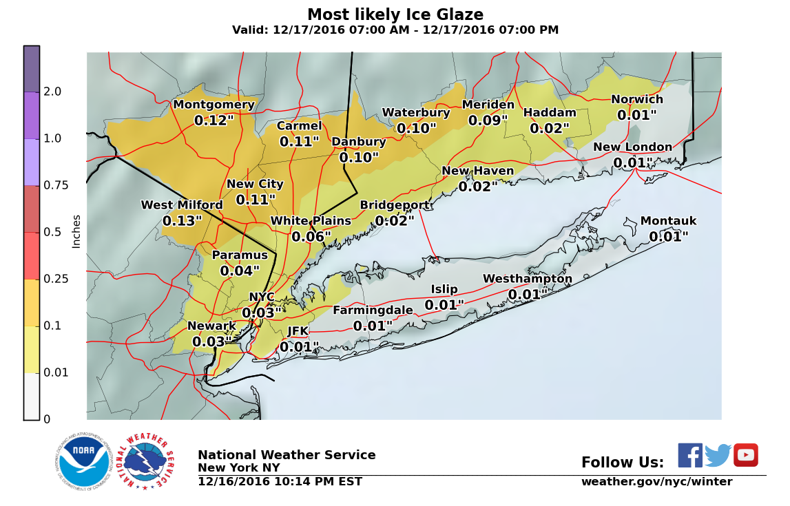
Winter Weather Advisory midnight tonight through tomorrow 1:00 pm for snow and freezing rain.
Snow tonight, mainly after midnight, 1 - 2"
Snow changes over to rain mid to late morning tomorrow. 1 - 3" more snow, possible freezing rain causing icing during the changeover.
Rain continues through the weekend with rising temps.

There will be a Winter Weather Advisory from Midnight tonight until 1:00 pm Saturday
Critical times in the MAPSO area will be:
1) Midnight - early morning. Snow, 1 - 3"
2) Early morning until noon. Possible icing as snow changes over to rain.
National Weather Service advisory below:
Winter Weather Advisory
URGENT - WINTER WEATHER MESSAGE
NATIONAL WEATHER SERVICE NEW YORK NY
340 PM EST FRI DEC 16 2016
...WINTRY WEATHER EXPECTED TONIGHT INTO SATURDAY...
CTZ005>012-NJZ004-103>108-NYZ069>071-170500-
/O.CON.KOKX.WW.Y.0016.161217T0500Z-161217T1800Z/
NORTHERN FAIRFIELD-NORTHERN NEW HAVEN-NORTHERN MIDDLESEX-
NORTHERN NEW LONDON-SOUTHERN FAIRFIELD-SOUTHERN NEW HAVEN-
SOUTHERN MIDDLESEX-SOUTHERN NEW LONDON-EASTERN PASSAIC-
WESTERN BERGEN-EASTERN BERGEN-WESTERN ESSEX-EASTERN ESSEX-
WESTERN UNION-EASTERN UNION-ROCKLAND-NORTHERN WESTCHESTER-
SOUTHERN WESTCHESTER-
340 PM EST FRI DEC 16 2016
...WINTER WEATHER ADVISORY REMAINS IN EFFECT FROM MIDNIGHT
TONIGHT TO 1 PM EST SATURDAY...
* LOCATIONS...SOUTHERN CONNECTICUT AND EASTERN PASSAIC...
BERGEN...ESSEX...AND UNION IN NEW JERSEY AND ROCKLAND AND
WESTCHESTER IN NEW YORK.
* HAZARD TYPES...SNOW AND FREEZING RAIN.
* SNOW ACCUMULATIONS...2 TO 4 INCHES.
* ICE ACCUMULATIONS...UP TO A TENTH OF AN INCH.
* TIMING...SNOW TONIGHT CHANGING TO FREEZING RAIN SATURDAY MORNING.
* IMPACTS...HAZARDOUS TRAVEL CONDITIONS ARE EXPECTED DUE TO SNOW AND ICE.
* TEMPERATURES...RISING FROM THE LOWER 20S TO THE LOWER 30S BY MID MORNING.
PRECAUTIONARY/PREPAREDNESS ACTIONS...
A WINTER WEATHER ADVISORY MEANS THAT PERIODS OF SNOW...SLEET...OR FREEZING RAIN WILL CAUSE TRAVEL DIFFICULTIES. BE PREPARED FOR SLIPPERY ROADS AND LIMITED VISIBILITIES...AND USE CAUTION WHILE DRIVING.
Oh, and more rain on Sunday, but temperatures will be above freezing.

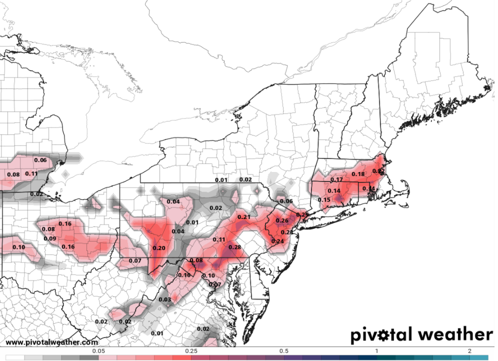
Max -what's your thoughts on discussions on weather boards about 1/4" of ice Saturday? Credible?
wharfrat said:
Max -what's your thoughts on discussions on weather boards about 1/4" of ice Saturday? Credible?
Not here. North and west, especially through the gunks and catskills, it's a possibility. Here, very unlikely.
Total qpf for the event is forecast at .5 - 1", so .25" of ice would mean 1/2 the precitation as ice. I just do not see the temp profile for that.


Max, Need to get to Hartford, CT by 4pm Saturday. If you had to drive it, would you go I 84 or use I 95 then head north? Many Thanks, Man! Plan on leaving here around 12:30pm
-Ron Carter
max_weisenfeld said:I loved wunderground's wundermap for radar, but after the buyout they mucked it up and it still has not regained all the functionality it had. I do not use the rest of their tools. All the data come from the NWS, so I go to the source. The NWS version of the graphs is here: http://forecast.weather.gov/MapClick.php?lat=40.7331&lon=-74.2719&unit=0&lg=english&FcstType=graphical It seems to show the wind the way they are forecasting it.
Thanks Max! I have bookmarked it! 
rcarter31 said:
Max, Need to get to Hartford, CT by 4pm Saturday. If you had to drive it, would you go I 84 or use I 95 then head north? Many Thanks, Man! Plan on leaving here around 12:30pm
-Ron Carter
Speaking only from a weather aspect, 95. The coast will be warmer, less likely to have ice.
Freezing rain now falling across the area. Measured 2.2" of snow at 8:40, with some compaction (settling) from the rain. There was .43" of liquid water, so the snow may have been as deep as 3 - 4" before the rain changeover started. No measurable ice from the rain, but raods may have a glaze on them. Be careful!
Sponsored Business


Promote your business here - Businesses get highlighted throughout the site and you can add a deal.


The National Weather Service has issues a Wind Advisory for tomorrow from 9:00 am until 6:00 pm, when it upgrades to a High Wind Watch.
"A High Wind Watch means there is the potential for a hazardous wind event, with sustained winds of at least 40 mph or gusts of 58 mph or more."
Overnight low expected to be around 12. Wind chill around zero.
Friday will be a sunny, balmy 25.
Overnight Friday, snow, with potential accumulations of 1 - 2"
Snow continues into the morning, changing over to rain by 10am.
There could be some icing during the changeover.
I'll keep you posted on any changes.