Winter Sunday? Maybe not so much.


A friend of mine in Basking Ridge heard thunder this morning.
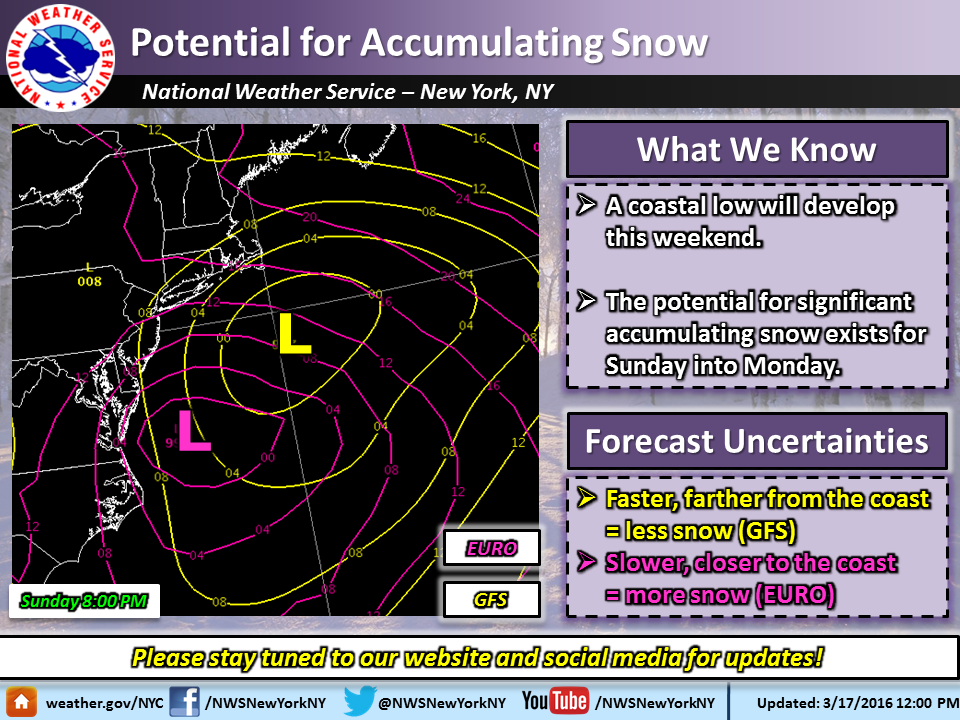
The reports I am seeing say 1-3 inches of snow Sunday night is possible. But it is a Nor'Easter and I have seen some of those become big snow producers in March. Many moons ago I skiied a foot of fresh powder at Jay Peak in mid-March after one of these.
I'm not yet convinced it will be organized enough to be a nor'easter. It is a messy set-up and there is still significant track divergence between the Euro and the GFS. Remembering that the GFS has been marginally better than the Euro this year (at least with this type of storm) and it is the GFS that has the more out-to-sea solution, I would be very hesitant to start putting any snow depth range on this at all. Track and temps are still too unsettled, and no one really cares about QPF this time of year unless it is frozen.
All that notwithstanding, yes, we have gotten hammered more than once at or beyond the equinox.

Also, right now the thunderstorms look like they will head north of us, although they will hit the city.
Ha, I bet the Weather Channel already has this one named and is predicting over a foot of snow, along with marauding zombies.


mfpark said:
Ha, I bet the Weather Channel already has this one named and is predicting over a foot of snow, along with marauding zombies.
What letter are we up to? I think the last one was Winter Storm Orca.

Still waiting for the NWS afternoon update -- they are late, which is not a good sign.
The last run of the Euro showed a serious storm. The GFS is still showing much less. Will update when NWS New York gets themselves sorted. The weenies are getting excited, though.

I have a flight on Tuesday at 11am. That's all I care about! Ugh!

ABC News just indicated that the greatest probability at this point in time is 6+ inches from Sunday into Monday.
For the first time the NWS is now referring to a potential nor'easter.
There is still a significant divergence between the major models, with the Euro favoring a solution that could mean a foot of snow for our area. Precipitation in the GFS is also most likely snow, although significantly less, around 4 - 6". At this time all model solutions are low confidence, though.
Timing is slower this set of runs, with the snow starting Sunday midday and running all night (the most aggressive solutions have snow through the morning rush on Monday).
While it is still too early to make accurate snowfall predictions, especially for a storm this late in the season, be aware that there is the potential for significant snowfall with this system across the entire northeast.
There is also right now a nice little thunderstorm to our north, but it looks like this one will miss us, too, and that we will not have any fun at all today.

ugh. Driving to Pittsburgh this weekend. Id rather leave Saturday early evening but daughter wants to stay an extra day. I did just get new tires but don't have 4wd. I really don't like driving, let alone with precipitation. Thoughts?

is it a late day Sunday thing into Monday or will Sunday be a bust?
At this time -- and this is quite subject to change -- we are looking at midday Sunday through Monday morning.

So I'd better get my run in first thing Sunday morning. Good to know!!
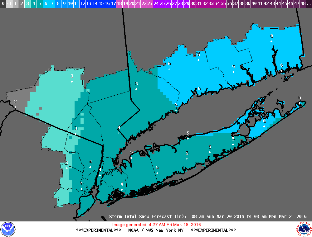
The overnight model runs still show a faily large spread, with some shifting to the east in the track among the models that were showing the highest snowfall. This would take more of the snow offshore, and keep temps a bit warmer, especially during the day Sunday.
Best guess at this time would have snow likely on Sunday, starting midday, with only light to moderate intensity and little accumulation, an inch or two.
Then snow likely overnight Sunday, moderate intensity, with accumulation of 4 to 6 inches overnight.
Snow might continue into Monday morning's commute.
The NWS still considers this a low confidence forecast, though, with a significant upside if the storm tracks closer to the coast as some models are showing.
Hazardous Weather Outlook
HAZARDOUS WEATHER OUTLOOK
NATIONAL WEATHER SERVICE NEW YORK NY
424 AM EDT FRI MAR 18 2016
THIS HAZARDOUS WEATHER OUTLOOK IS FOR SOUTHERN
CONNECTICUT...NORTHEAST NEW JERSEY AND SOUTHEAST NEW YORK.
.DAY ONE...TODAY AND TONIGHT.
HAZARDOUS WEATHER IS NOT EXPECTED AT THIS TIME.
.DAYS TWO THROUGH SEVEN...SATURDAY THROUGH THURSDAY.
THERE IS A POTENTIAL FOR A COASTAL STORM THAT COULD BRING AT
LEAST 6 INCHES OF SNOW TO THE TRI-STATE AREA ALONG WITH STRONG
WINDS AND MINOR COASTAL FLOODING.
.SPOTTER INFORMATION STATEMENT...
SPOTTER ACTIVATION IS NOT EXPECTED AT THIS TIME.
&&
THIS HAZARDOUS WEATHER OUTLOOK PROVIDES A SUMMARY OF POTENTIAL
WIDESPREAD HAZARDOUS WEATHER EVENTS THAT MAY REACH NWS WARNING
CRITERIA. MOST LONG FUSED NWS WATCHES...WARNINGS AND ADVISORIES IN
EFFECT ARE HIGHLIGHTED.
PLEASE REFER TO THE LATEST NWS FORECASTS FOR WEATHER NOT MEETING NWS
WARNING CRITERIA.
Right now the trend is encouraging for this to be a nuisance snowfall rather than a storm. Less talk of a nor'easter on the boards this morning, too.
If you are keeping score at home, this is the fourth time this winter the GFS has had the better read at 5 days out over the Euro. USA! USA! USA!
conandrob240 said:
so what's the timing?
Still midday Sunday to Sunday night, with little accumulation Sunday.
The long-range models only really digest new data in 12 hour chunks, and until 36 hours out (overnight tonight) we are still really in long-range model territory. So I am still working with last night's runs, and won't see really new information until this afternoon. Expect the NWS to make serious changes to the forecast around 4:00pm, unless there is a dramatic shift that requires urgent notice.
Because I am hearing snow will start in the am on Sunday and then get heavy around 3pm, that's why I keep asking. Both forecasts show snow developing around 6am. This makes a difference to me in deciding our plans
Don't count out the Euro model just yet!
As you noted, NWS is saying they will not make a solid forecast until later today. Some models are showing the storm center staying closer to land, meaning more rain for us. But the Euro is hanging in there!
conandrob240 said:
Because I am hearing snow will start in the am on Sunday and then get heavy around 3pm, that's why I keep asking. Both forecasts show snow developing around 6am. This makes a difference to me in deciding our plans
All I can do is give you my best understanding. I really do not have the facility or interest to rebut other forecasts. I really have no new data since I posted what I said above, at least not enough to change my mind. Keep your plans flexible, no one is going to be able to give you clear guidance before tomorrow morning. Take any forecast made now with caution, things are simply not that clear cut. I think we have seen that with timing on these systems, things will still be shifty until Sunday morning.
The midday runs have not really clarified things, but the overall trend still seems to be for a weaker, later event. However, there are significant outliers in the models that indicate more snow.
Based on this, the NWS is waiting for tonight's model runs to call the storm, and are wrapping caveats with conditions within qualifications in their forecast.
That said, here is what they are saying:
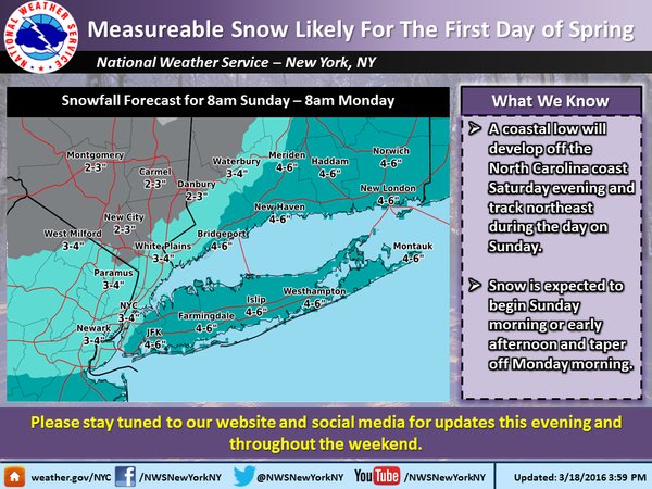
Snow starts lightly after midday Sunday, and at first there would be little accumulation, especially on road surfaces. As the snow picks up and the sun goes down, snow will start to accumulate, with perhaps a total of 2 - 5" by morning. Snow ends very early Monday morning, with some snow showers possible until Monday midday.
That said, I am hopeful. The trend is good, the system is weakening, the weenies are despairing, the GFS has read these better than the Euro all season and the Euro is caving towards the GFS solution now. I do think we will see some snow, especially Sunday evening, but I think at this point it will be at the lower end of the predicted range.

Max, you are the best!  To provide us this info is so generous. Never, ever leave us.


There is a very real possibility of accumulating snow Sunday.
At this time, snow would start during the day Sunday and continue into the evening and possibly through part of Sunday night. At any time during the event, rain could mix in.
While frustrating, it is not at all unusual to have snow this late in the season.
The morning commute could be affected if cleanup is still ongoing, but at this time it looks like the precipitation will be over by then. Temps in the mid 40s and partly sunny conditions Monday means the snow will not hang around unless we get more than most guidance is indicating at this time.