Hurricane Florence and Potential Local Impacts

jamie said:
Was the downgrade to a category 3 expected this soon?
Not quite this soon. A process called an "eyewall replacement cycle" (ERC) occurred but didn't finish. Effectively, the eye of the hurricane takes on multiple concentric eyewalls, with the outer eyewall effectively killing off the inner one. This generally does two things: 1) makes the size of the storm much bigger; 2) temporarily weakens the storm. In this case, the ERC was unable to complete, meaning that part of the eyewall remained open and allowed for dry air to be sucked into the core of the storm. This dry air aided in a slight weakening. Due to this, as well as the increasingly unfavorable conditions for further intensification, it's slightly unlikely (although far from impossible) it gets back up to cat 4 let alone cat 5. ERC's are nearly impossible to simulate in the models we have today and are the types of phenomena that lead to immense uncertainty in the forecasts.
The weakening though is a double edged sword. On the one hand, the storm is a little weaker which is good. On the other hand(s), the strength though is sort of semantic because we get caught up in the categories rather than the true intensity. The difference between a high-end cat 3 and a low-end cat 4 is negligible in terms of impacts, but typically results in people letting their guard down. The other issue is the shear size of the storm. Each ERC increases the radius the hurricane force winds extending from the center. Typically, hurricane force winds are restricted to an area very close to the eye. In this case, they extend out to something like 90 miles. So in addition to a larger area being exposed to hurricane force wind, it means the total energy encapsulated within the cyclone is greater than it was before. When you consider the impact that's going to have on the storm surge, its pretty daunting. Make no mistake, even if this thing weakens further, it's still going to have a catastrophic storm surge. What makes it even worse is the geometry of the coastline. The angle of approach by the storm in conjunction with the angle of the coastline is going to aid in the creation of something called a "trapped oceanic kelvin wave", which is effectively a slow moving oscillation under the surface (this isn't anything like normal ocean waves) that is going to cause water to recede slower than normal. When you consider this on top of the fact that this thing could stall and drop 40+ inches of rain, its just not good.
You can see clearly on Microwave satellite Imagery (shameless plug for my Grad School UW-Madison and our satellite division CIMSS/SSEC) a 24-hr loop of the eyewall. Microwave imagery is able to look through the clouds and determine water phase (liquid, ice, etc.) in determining the intensity of the eyewall. You can clearly see in the loop several instances of concentric eyewalls and the final, unfinished ERC. The top left corner of the loop also shows something called Vmax, which is the satellite estimated maximum wind velocity in the storm. You can see it going down as the ERCs occur, especially so with the last one.
max_weisenfeld said:
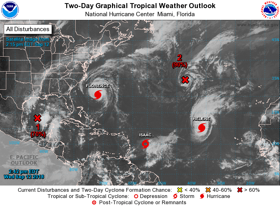
All the stormsies.
The "X" in the Gulf is likely to become a tropical storm and rain on Texas and Louisiana. Isaac will most likely not make it to hurricane strength before it crosses the windward islands. Helene is staying our to sea, and is the "X" in the North Atlantic.
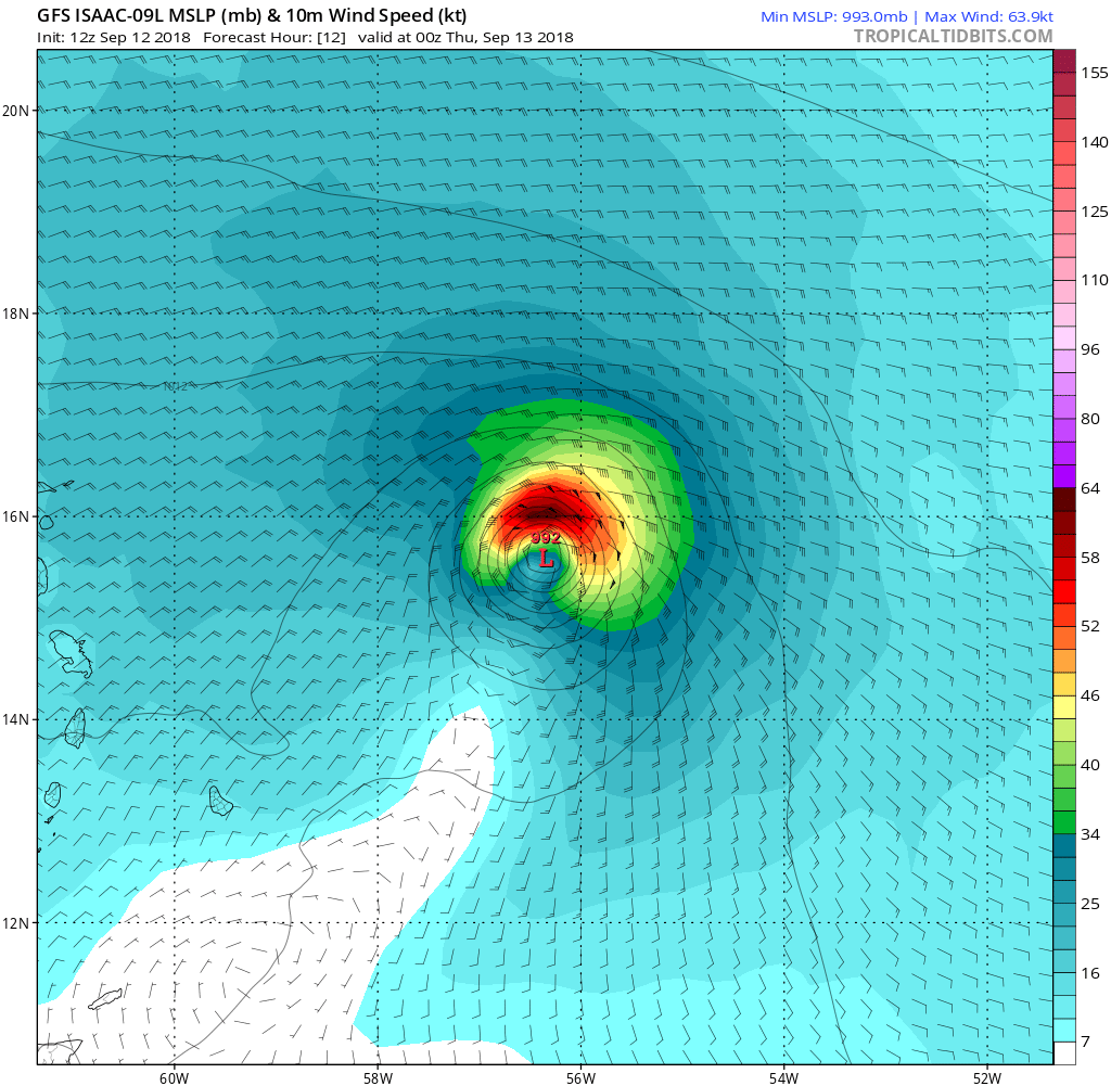
Happy hour GFS likes Isaac...a lot.

conandrob240 said:
WxNut2.0 said:Then they need a financial deterrent. Fines or insurance revoked. If their lives aren’t important to them, maybe $ would be
conandrob240 said:They've already stated they won't be doing any rescue operations during the hurricanes. Mandatory evacuations basically mean you're on your own and that's what will happen, unfortunately.
people that stay put when there's a mandatory evacuation warning are being reckless but also selfish. If you make that call against mandatory evacuation, you should not be entitled to any rescue or support services.
One would assume that if one’s own life isn’t a significant enough deterrent to winning a Darwin Award, a shot to the pocketbook wouldn’t be. The facts and warnings are there. The calculated (or not, evidently) risk should be theirs alone to bear.


WxNut2.0 said:
max_weisenfeld said:Happy hour GFS likes Isaac...a lot.
All the stormsies.
The "X" in the Gulf is likely to become a tropical storm and rain on Texas and Louisiana. Isaac will most likely not make it to hurricane strength before it crosses the windward islands. Helene is staying our to sea, and is the "X" in the North Atlantic.
So does the SHIFOR, but i don't actually know what that one is.
Is this (graphic below) what you are talking about? Looks like it does not quite make it.


You know what would be useful is a topographical map of the shoreline which showed elevations so that you could sort of gauge whether you were under threat of the storm surge. I can understand people who don't want to evacuate, but if your first floor is going to be inundated, you'd probably best get your butts out of there. But it's not clear that people have a good sense of whether they're in danger of that or not. Unless you live right on the shore, of course.
Anyway, Max and wxnut - can you get on that please? 
drummerboy said:
You know what would be useful is a topographical map of the shoreline which showed elevations so that you could sort of gauge whether you were under threat of the storm surge. I can understand people who don't want to evacuate, but if your first floor is going to be inundated, you'd probably best get your butts out of there. But it's not clear that people have a good sense of whether they're in danger of that or not. Unless you live right on the shore, of course.
Anyway, Max and wxnut - can you get on that please?

Ask and ye shall (kind of) receive:
https://www.nhc.noaa.gov/refresh/graphics_at1+shtml/212431.shtml?inundation#contents
Turn on/off the labels on the top right.

drummerboy said:
You know what would be useful is a topographical map of the shoreline which showed elevations so that you could sort of gauge whether you were under threat of the storm surge. I can understand people who don't want to evacuate, but if your first floor is going to be inundated, you'd probably best get your butts out of there. But it's not clear that people have a good sense of whether they're in danger of that or not. Unless you live right on the shore, of course.
Anyway, Max and wxnut - can you get on that please?
If you go to the layers list and turn on the layer named "3DEP Elevation - Auto Contours" you can see the elevation contours for the area, once you've zoomed in far enough.
You can get the elevation of a point by clicking on the map and scrolling down in the pop up window to the "Service Pixel Value" line.
You can also get an elevation profile along a line by clicking the profile button at the top of the map.
If you have access to GIS software you can also download the base data for your own visualization from here

ctrzaska said:
conandrob240 said:One would assume that if one’s own life isn’t a significant enough deterrent to winning a Darwin Award, a shot to the pocketbook wouldn’t be. The facts and warnings are there. The calculated (or not, evidently) risk should be theirs alone to bear.
WxNut2.0 said:Then they need a financial deterrent. Fines or insurance revoked. If their lives aren’t important to them, maybe $ would be
conandrob240 said:They've already stated they won't be doing any rescue operations during the hurricanes. Mandatory evacuations basically mean you're on your own and that's what will happen, unfortunately.
people that stay put when there's a mandatory evacuation warning are being reckless but also selfish. If you make that call against mandatory evacuation, you should not be entitled to any rescue or support services.
People aren’t all that bright so I wouldn’t be so sure of that.

If you don't want to get off the damn beach, go on the internet tubes and google: "Hurricane 1938"
On the other hand, all this could just be fake news to allow Dems to raise taxes to give to illegal immigrants.

Dr. WixNut and Max, thank you both so much for answering my questions. I was kind of thinking it was too soon to say Savannah was in the clear. Will still wait and watch, and encourage my Savannah people to stay tuned and be prepared. Frightening that some in North Carolina are staying put, on the islands, no less.
As usual, really appreciate these threads and your expertise in sorting it all out.

What caused the projected path of the hurricane to move south this morning?
WxNut2.0 said:
drummerboy said:Ask and ye shall (kind of) receive:
You know what would be useful is a topographical map of the shoreline which showed elevations so that you could sort of gauge whether you were under threat of the storm surge. I can understand people who don't want to evacuate, but if your first floor is going to be inundated, you'd probably best get your butts out of there. But it's not clear that people have a good sense of whether they're in danger of that or not. Unless you live right on the shore, of course.
Anyway, Max and wxnut - can you get on that please?
https://www.nhc.noaa.gov/refresh/graphics_at1+shtml/212431.shtml?inundation#contents
Turn on/off the labels on the top right.
Excellent!
The icky news I've been hearing today is what's going to happen to all of those poop lakes associated with the many industrial pig farms in the area.
Don't even want to think about that mess.
drummerboy said:
The icky news I've been hearing today is what's going to happen to all of those poop lakes associated with the many industrial pig farms in the area.
Don't even want to think about that mess.
The good news is that after Floyd, both Carolina's passed more stringent regulations regarding the manure lagoons to reduce the chances that they'd overflow during heavy rain or that floodwaters could carry away the contents.
The bad news is that Florence's rainfall is likely to be so exceptional in portions of both states that the hazard will exceed the flood defense design capacities.
PetuniaBird said:
What caused the projected path of the hurricane to move south this morning?
Very weak winds over the depth of the atmosphere to push it in any direction, in conjunction with a strong ridge of high pressure to the north that it was unable to push through.
conandrob240 said:
all the way down to a 2 already?
One mph short of a 3. Which means its impacts are effectively the same. We need a better scale.

So not to be too mercenary about it but imagine what this "trend" of worsening hurricanes will do to property values from Maine to Miami to Houston to Seattle, inland fifty to a hundred miles anywhere near rivers and streams in America.
Florence is predicted to climb up into the Appalachians inland in the Carolinas. Wouldn't that compare to a climb in NJ into Sussex County?
Out here at the end of I-78 in NJ, we had flooding not in Sandy, but on the Delaware, its Canals and its tributaries during Floyd, Ivan and Irene, when floods hit lakes and reservoirs in upstate New York, overfilled by Trout Unlimited among others. Although this practice was stopped in discussions with officials in New Jersey, Pennsylvania and New York, we still, at this moment, have the effects of violent flooding in the Delaware Water Gap, Worthington State Forest, and nearly impassible roads up near Layton and Walpack. This summer"s rainfall, alone, has become really devastating up here in the Pocono foothills.

drummerboy said:
poop lakes
Komarovsky said:manure lagoons
We had some friends who moved to S. Carolina a few years ago and I thought they were crazy then but this kicks things up a notch.
WxNut2.0 said:
conandrob240 said:One mph short of a 3. Which means its impacts are effectively the same. We need a better scale.
all the way down to a 2 already?
Central pressure should be the standard, it's a continuous variable and all. Millibars are communist moon units though so no god fearing American would ever use them.
GoSlugs said:
drummerboy said:
poop lakes
Komarovsky said:manure lagoonsWe had some friends who moved to S. Carolina a few years ago and I thought they were crazy then but this kicks things up a notch.
Yeah, just give me the toxic superfund soup of the flooded Passaic River any day! ☠
Komarovsky said:
WxNut2.0 said:Central pressure should be the standard, it's a continuous variable and all. Millibars are communist moon units though so no god fearing American would ever use them.
conandrob240 said:One mph short of a 3. Which means its impacts are effectively the same. We need a better scale.
all the way down to a 2 already?
Bump
peaceinourtime said:
GoSlugs said:Yeah, just give me the toxic superfund soup of the flooded Passaic River any day! ☠
drummerboy said:
poop lakes
Komarovsky said:manure lagoonsWe had some friends who moved to S. Carolina a few years ago and I thought they were crazy then but this kicks things up a notch.
Touche. NJ for the culture, South Carolina for the water sports.
In any case, I wish the people down there well. If the dice had rolled the other way, it could be us staring down the barrel of this gun.
GoSlugs said:
peaceinourtime said:Touche. NJ for the culture, South Carolina for the water sports.
GoSlugs said:Yeah, just give me the toxic superfund soup of the flooded Passaic River any day! ☠
drummerboy said:
poop lakes
Komarovsky said:manure lagoonsWe had some friends who moved to S. Carolina a few years ago and I thought they were crazy then but this kicks things up a notch.
In any case, I wish the people down there well. If the dice had rolled the other way, it could be us staring down the barrel of this gun.
Indeed!

GoSlugs said:
peaceinourtime said:Touche. NJ for the culture, South Carolina for the water sports.
GoSlugs said:Yeah, just give me the toxic superfund soup of the flooded Passaic River any day! ☠
drummerboy said:
poop lakes
Komarovsky said:manure lagoonsWe had some friends who moved to S. Carolina a few years ago and I thought they were crazy then but this kicks things up a notch.
In any case, I wish the people down there well. If the dice had rolled the other way, it could be us staring down the barrel of this gun.
Not just water sports...Golf capital of the world.

WxNut2.0 said:
jamie said:Not quite this soon. A process called an "eyewall replacement cycle" (ERC) occurred but didn't finish. Effectively, the eye of the hurricane takes on multiple concentric eyewalls, with the outer eyewall effectively killing off the inner one. This generally does two things: 1) makes the size of the storm much bigger; 2) temporarily weakens the storm. In this case, the ERC was unable to complete, meaning that part of the eyewall remained open and allowed for dry air to be sucked into the core of the storm. This dry air aided in a slight weakening. Due to this, as well as the increasingly unfavorable conditions for further intensification, it's slightly unlikely (although far from impossible) it gets back up to cat 4 let alone cat 5. ERC's are nearly impossible to simulate in the models we have today and are the types of phenomena that lead to immense uncertainty in the forecasts.
Was the downgrade to a category 3 expected this soon?
The weakening though is a double edged sword. On the one hand, the storm is a little weaker which is good. On the other hand(s), the strength though is sort of semantic because we get caught up in the categories rather than the true intensity. The difference between a high-end cat 3 and a low-end cat 4 is negligible in terms of impacts, but typically results in people letting their guard down. The other issue is the shear size of the storm. Each ERC increases the radius the hurricane force winds extending from the center. Typically, hurricane force winds are restricted to an area very close to the eye. In this case, they extend out to something like 90 miles. So in addition to a larger area being exposed to hurricane force wind, it means the total energy encapsulated within the cyclone is greater than it was before. When you consider the impact that's going to have on the storm surge, its pretty daunting. Make no mistake, even if this thing weakens further, it's still going to have a catastrophic storm surge. What makes it even worse is the geometry of the coastline. The angle of approach by the storm in conjunction with the angle of the coastline is going to aid in the creation of something called a "trapped oceanic kelvin wave", which is effectively a slow moving oscillation under the surface (this isn't anything like normal ocean waves) that is going to cause water to recede slower than normal. When you consider this on top of the fact that this thing could stall and drop 40+ inches of rain, its just not good.
You can see clearly on Microwave satellite Imagery (shameless plug for my Grad School UW-Madison and our satellite division CIMSS/SSEC) a 24-hr loop of the eyewall. Microwave imagery is able to look through the clouds and determine water phase (liquid, ice, etc.) in determining the intensity of the eyewall. You can clearly see in the loop several instances of concentric eyewalls and the final, unfinished ERC. The top left corner of the loop also shows something called Vmax, which is the satellite estimated maximum wind velocity in the storm. You can see it going down as the ERCs occur, especially so with the last one.
WxNut2.0: That was an amazing explanation. Great job! And great job, Max! You two are the best!

NotoriousEAM said:
WxNut2.0 said:WxNut2.0: That was an amazing explanation. Great job! And great job, Max! You two are the best!
jamie said:Not quite this soon. A process called an "eyewall replacement cycle" (ERC) ...
Was the downgrade to a category 3 expected this soon?
Completely agree. A masterful explanation.
And the very best congratulations on you doctorate, WxNut. You certainly hit the jackpot in picking meteorology. A career that can't help but grow in importance and excitement.
Sponsored Business


Promote your business here - Businesses get highlighted throughout the site and you can add a deal.


All the stormsies.
The "X" in the Gulf is likely to become a tropical storm and rain on Texas and Louisiana. Isaac will most likely not make it to hurricane strength before it crosses the windward islands. Helene is staying our to sea, and is the "X" in the North Atlantic.