Winter Storm Wednesday 3/7


My employees outside Philly are telling me they are getting hit with as much as 3" per hour. 8" already fallen, along with many trees. Are we going to get the same up here?

Just finished the first pass on Courter. Snow was heavy but manageable given the light accumulation thus far. Tried to get to the Prospect side and couldn't given hidden ruts in the lawn (from downed tree) and wall of ice in the street (from plowing on Prospect). Prospect sidewalk may have wait until tomorrow when street conditions should improve. Please be careful if you try to cut across my lawn to avoid the tree-torn-up sidewalk by the crosswalk. DPW really tore it up and worst will be hidden by snow fall as storm intensifies.


Yeah, this is looking like at least a 'twice' clearing storm. Think I'm going to wait until around dusk, then see what it looks like and what the forecast is, at that time.

jim4284 said:
I would think starting so late saved us from getting over 15 inches. I will take 6 inches or so at this point.
That’s what she said

Oh snap 
spontaneous said:
jim4284 said:
I would think starting so late saved us from getting over 15 inches. I will take 6 inches or so at this point.
That’s what she said

Speak English!
WxNut2.0 said:
Looking at some real time analysis, there is strong deformation occurring over a deep vertical layer indicative of frontogenesis. In addition that, the environment appears primed along the band for the release of "slantwise instability", which is well known to occur in areas of banded precip like that, but can also help to rapidly increase the intensification rate of the storm itself. So I'd be on the lookout for at lease some more intensification of this thing. As for that band, the more I look the more I think it may be a bent back warm-front, especially given the deeper-upright convection to its east, and that the frontogenesis function is sloping in such a manner consistent with a warm front.

lol. my thoughts exactly.
yahooyahoo said:
Speak English!
WxNut2.0 said:
Looking at some real time analysis, there is strong deformation occurring over a deep vertical layer indicative of frontogenesis. In addition that, the environment appears primed along the band for the release of "slantwise instability", which is well known to occur in areas of banded precip like that, but can also help to rapidly increase the intensification rate of the storm itself. So I'd be on the lookout for at lease some more intensification of this thing. As for that band, the more I look the more I think it may be a bent back warm-front, especially given the deeper-upright convection to its east, and that the frontogenesis function is sloping in such a manner consistent with a warm front.
Translation:
"Thundersnow": check
"Quick transition to heavy snow": check
"Max, that band you are looking at on the radar will probably miss one, but it is the first of several": check


I enjoy the complexities of weather forecasting and the terms that are used sometimes make for interesting problems in communication. Here is a favorite video of mine -- the famous Turbo Encabulator presentation. There are now many variants of this video, but I do show it to my students from time to time.
Definitely not over yet. There is a monster band heading inland from just south of Long Island. If it hits us, that's four inches right there.
It really depends on the location of the heaviest snow, and that is not really forecastable, it is just wait-and-see-able.
By the way, my forecast was 8-10"
The NWS went to 12" and they are very good at what they do, but the tools they use for a system this complex are beyond what I understand, so at that point I just quote them.

Ya this
max_weisenfeld said:
yahooyahoo said:
Speak English!
WxNut2.0 said:
Looking at some real time analysis, there is strong deformation occurring over a deep vertical layer indicative of frontogenesis. In addition that, the environment appears primed along the band for the release of "slantwise instability", which is well known to occur in areas of banded precip like that, but can also help to rapidly increase the intensification rate of the storm itself. So I'd be on the lookout for at lease some more intensification of this thing. As for that band, the more I look the more I think it may be a bent back warm-front, especially given the deeper-upright convection to its east, and that the frontogenesis function is sloping in such a manner consistent with a warm front.
Translation:
"Thundersnow": check
"Quick transition to heavy snow": check
"Max, that band you are looking at on the radar will probably miss one, but it is the first of several": check


when I say it, it sounds like it needs an extra syllable - it should be fronteogenesis.
angelak said:
Frontogenesis is my new favorite word.
mem said:
11” - 17”?
https://forecast.weather.gov/MapClick.php?lat=40.7239&lon=-74.2571#.WqBR7spOmf3
Given how this has evolved, it’s definitely possible.
smelni said:
when should we start shoveling?
Up to you. I have already made a few passes because I don't want to lift a lot of weight at one time.

smelni said:
when should we start shoveling?
Just did a first pass. No more than three inches, but it is HEAVY. Seriously heavy. Wouldn't want to shovel six inches of that, not to mention 12-18. I'd say get out there now, then at least one more time before bed.
joan_crystal said:
smelni said:
when should we start shoveling?
Up to you. I have already made a few passes because I don't want to lift a lot of weight at one time.
Admit it, you just like shoveling! ;-)

We are WAY past 12" here in Morristown from what I can see, and it is still coming down at a thick and heavy rate. I am contemplating a first shovel but also have bronchitis......

This is a rough storm for the trees. We have lost major branches on our tall cedars. One busted through a storm window in our Maplewood room. The sound of tree limbs breaking makes me so sad.

we went out to shovel but came inside when some BIG branches came down nearby. I expect there will be a lot of downed trees and limbs - and they are falling now,. BE CAREFUL - it can be very very dangerous out there.

you can never convince me that shoveling twice is better than once. Tomorrow morning or late tonight. Just lift less snow on each scoop. Better than doing it all twice

I saw one flash of lightning and heard the one resulting thunderclap. Have there been any more?

I just made a first pass with both the shovel (deck & steps) and the snowblower (driveway and sidewalks). It is very heavy, and in some lower areas it is so wet it clogs the shoot on the blower. It's also coming down so fast that where I started shoveling already looks pretty much like it did in the first place. But, as I told my neighbor, I like to keep it cleared enough to know where the boundaries of the drive and the sidewalks are.
For Sale
-
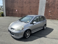
2007 Honda Fit $4,400
More info


Free Items
Sponsored Business


Promote your business here - Businesses get highlighted throughout the site and you can add a deal.

I came home on the 1:11 train out of the city. Train made all the stops right on time, but several cars were struggling in the Maplewood Station parking lot. I slid around quite a bit on my way home, in a Honda Element with all-wheel drive. Be careful out there.