Winter Storm Wednesday 3/7


FilmCarp said:
But still nothing compared to what our fellow citizens in Puerto Rico are still going through.
Right. It kind of puts it in perspective.
Jesus, what has happened to this country?

Probably not the last one of the season either btw. Pattern for the next couple of weeks will remain conducive. Hopefully I jinx it.


One of my friends in PR reported last week being on day 162 without power. I can't even imagine.


Would any of our previous presidents abandon Puerto Rico the way this fake one has? It’s heinous.

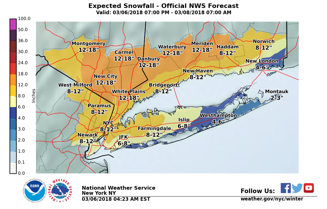
Winter Storm Warning in effect from Tuesday night through early Thursday morning for snow, heavy at times. Total accumulation 10" - 12" possible.
The forecast is coming into better focus, and the image is likely to be snow. Although there is still some significant uncertainty as to the exact track of the storm, snow is dominant in most versions. Precipitation will start falling early Wednesday, perhaps as light rain, but by Wednesday morning when things should really get going it will likely change over to all snow.
Then snow, which could set up in heavy bands which will determine final totals, with areas getting hit by the bands having higher accumulations. Snow rates in those heavier bands could exceed 1-2" per hour for a time. Snow should be steady all day and into the evening, ending during the night Wednesday or very early Thursday morning.
From the NWS:
"Winter Storm Warning
URGENT - WINTER WEATHER MESSAGE
National Weather Service New York NY
349 AM EST Tue Mar 6 2018
CTZ005>007-009>011-NJZ002-004-006-103>108-NYZ067>075-078-176>179-
061700-
/O.UPG.KOKX.WS.A.0006.180307T0500Z-180308T1100Z/
/O.NEW.KOKX.WS.W.0006.180307T0300Z-180308T0900Z/
Northern Fairfield-Northern New Haven-Northern Middlesex-
Southern Fairfield-Southern New Haven-Southern Middlesex-
Western Passaic-Eastern Passaic-Hudson-Western Bergen-
Eastern Bergen-Western Essex-Eastern Essex-Western Union-
Eastern Union-Orange-Putnam-Rockland-Northern Westchester-
Southern Westchester-New York (Manhattan)-Bronx-
Richmond (Staten Island)-Kings (Brooklyn)-Northwestern Suffolk-
Northern Queens-Northern Nassau-Southern Queens-Southern Nassau-
349 AM EST Tue Mar 6 2018
...WINTER STORM WARNING IN EFFECT FROM 10 PM THIS EVENING TO 4 AM
EST THURSDAY...
* WHAT...Heavy snow expected. Total snow accumulations of 6 to 12
inches, except 10 to 15 inches across interior portions of the
Lower Hudson Valley, and most of interior southern Connecticut.
Locally higher amounts are possible.
* WHERE...New York City, Northeast New Jersey, The Lower Hudson
Valley, Southwestern Connecticut, Middlesex, Nassau and
northwestern Suffolk Counties.
* WHEN...From 10 PM this evening to 4 AM EST Thursday.
* ADDITIONAL DETAILS...Travel will be very difficult to
impossible, including during the evening commute on Wednesday.
Be prepared for significant reductions in visibility at times.
PRECAUTIONARY/PREPAREDNESS ACTIONS...
A Winter Storm Warning for snow means severe winter weather
conditions will make travel very hazardous or impossible. If you
must travel, keep an extra flashlight, food and water in your
vehicle in case of an emergency. Check local Department of
Transportation information services for the latest road
conditions."


NotoriousEAM said:
Will there be significant winds to accompany the snowfall?
Not anywhere near the last storm, but likely some strong gusts in there.

I'll be riding my bike from Brooklyn to Manhattan over the Manhattan Bridge after 10pm tonight. I think I'm crazy.

@max_weisenfeld, the accumulation map you posted doesn't show anything in western New Jersey. Is there nothing of any significance expected out there, or does your map just show our area because we're all in Essex County and that is the only area you're discussing at the moment? I was talking to someone out in Flemington yesterday and he said that about 30,000 homes in the county still didn't have power. Add in the saturated ground and it won't take heavy snows or super strong winds to bring some more trees down out there.

That map only shows the NYC area: https://www.weather.gov/okx//winter
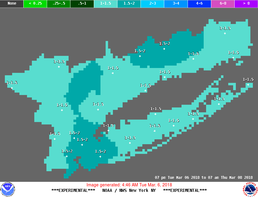
Here's a chart that estimates other areas:

spontaneous said:
@max_weisenfeld, the accumulation map you posted doesn't show anything in western New Jersey. Is there nothing of any significance expected out there, or does your map just show our area because we're all in Essex County and that is the only area you're discussing at the moment? I was talking to someone out in Flemington yesterday and he said that about 30,000 homes in the county still didn't have power. Add in the saturated ground and it won't take heavy snows or super strong winds to bring some more trees down out there.
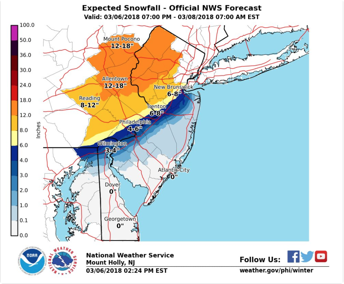
I'll field this one. It's only a map for the counties covered by NWS NYC. Here's the map covering the NWS Mt. Holly domain.

I'm out here, and although we have power so far, our neighbors do not and 10 inches of snow are expected overnight.
spontaneous said:
@max_weisenfeld, the accumulation map you posted doesn't show anything in western New Jersey. Is there nothing of any significance expected out there, or does your map just show our area because we're all in Essex County and that is the only area you're discussing at the moment? I was talking to someone out in Flemington yesterday and he said that about 30,000 homes in the county still didn't have power. Add in the saturated ground and it won't take heavy snows or super strong winds to bring some more trees down out there.
Models have actually begun to shift west today, only further making our lives more difficult. Its completely possible a major snow gradient sets up somewhere between NYC and Maplewood (if not further west), meaning that this storm still has major bust potential for the area. I'm fairly confident in a pretty big accumulation, but man this is a tough one. As always with these guys.


peaceinourtime said:
I'm out here, and although we have power so far, our neighbors do not and 10 inches of snow are expected overnight.
spontaneous said:
@max_weisenfeld, the accumulation map you posted doesn't show anything in western New Jersey. Is there nothing of any significance expected out there, or does your map just show our area because we're all in Essex County and that is the only area you're discussing at the moment? I was talking to someone out in Flemington yesterday and he said that about 30,000 homes in the county still didn't have power. Add in the saturated ground and it won't take heavy snows or super strong winds to bring some more trees down out there.
Ouch! The company I had contacted in Flemington was doing their best getting by using generators and using cell phones for internet since their computer internet was also down. Though the man seemed pretty chipper for being stuck in such a scenario 

NJ Closings are posted here:
http://itv2.news12.com/school_closings/school_closings_mobile.jsp?region=NJ&flag=1
From Maplewood Township: Storm Advisory
On Tuesday morning, Maplewood’s Emergency Preparedness Committee met to plan for the expected snow storm. Here the information as of 1:30pm Tuesday. We will update as needed.
1) In the event of an emergency call 911.
2) The County of Essex will declare a state of emergency at midnight on Wednesday and the Township will follow with its own emergency declaration. This means that non-essential automobile travel is prohibited. Additionally, no parking is permitted on snow emergency routes.
3) The Maplewood Jitneys will not operate in the morning or evening.
4) There will be no parking at the train station. This area must be kept clear for emergency vehicles and snow removing operations.
5) There will be no overnight parking permitted throughout town. All vehicles are expected to be removed from the roadway prior to midnight. This will help ensure snow removal and safe passage for emergency vehicles.
6) The Community Center in DeHart Park will open as a heating center and shelter. The Center, 120 Burnett Avenue, will open at 6am on Wednesday and stay open as long as needed. If you lose power and need a place to work or charge your electronic devices, you can use the Center. The Center’s phone number is 973-763-5287.
7) The Department of Public Works has 21 plows and 5 salt spreaders ready for action. Streets are not plowed until there is at least 3 inches of snow.
8) If you need to use a portable generator at your home, make sure it is well ventilated and not in a garage or other closed room.
9) The school district will make its determination on opening later this evening.
10) When shoveling your sidewalks and driveway, you are not allowed to throw the snow into the street.
11) Here’s information from Public Service Electric and Gas:
“Snow by itself normally doesn’t cause power outages,” said John Latka, PSE&G senior vice president of electric and gas operations. “But wind gusts and the heavy, soggy snow predicted for Wednesday could topple trees -- already in a weakened state -- and bring down nearby power lines with them. We also have some locations where we have made temporary repairs that won’t be permanently fixed in time for this next storm.
PSE&G will have personnel ready to respond to any outages and emergencies beginning Tuesday night. The utility is also ensuring that additional supplies, including poles, transformers and other pole-top equipment, are on hand. Employees work closely with county and municipal emergency management personnel to inform them of outages and expedite restoration efforts.
PSE&G urges its customers to be cautious during and after the storm:
Downed wires should always be considered “live.” Do not approach or drive over a downed line and do not touch anything that it might be in contact with.
To prevent carbon monoxide poisoning, do not run any gasoline powered engine, including generators and snowblowers, in a garage or any other enclosed space.
Customers should report downed wires or power outages by calling PSE&G’s Customer Service line at 1-800-436-PSEG. Also, customers can report outages at www.pseg.com or by texting “OUT” to 4PSEG (47734). The utility’s mobile-friendly website includes an “Outage Map” that is updated every 15 minutes and displays the location and status of power outages in PSE&G’s service area.
We find a way to get by!
spontaneous said:
peaceinourtime said:
I'm out here, and although we have power so far, our neighbors do not and 10 inches of snow are expected overnight.
spontaneous said:
@max_weisenfeld, the accumulation map you posted doesn't show anything in western New Jersey. Is there nothing of any significance expected out there, or does your map just show our area because we're all in Essex County and that is the only area you're discussing at the moment? I was talking to someone out in Flemington yesterday and he said that about 30,000 homes in the county still didn't have power. Add in the saturated ground and it won't take heavy snows or super strong winds to bring some more trees down out there.
Ouch! The company I had contacted in Flemington was doing their best getting by using generators and using cell phones for internet since their computer internet was also down. Though the man seemed pretty chipper for being stuck in such a scenario

WxNut2.0 said:
Models have actually begun to shift west today, only further making our lives more difficult. Its completely possible a major snow gradient sets up somewhere between NYC and Maplewood (if not further west), meaning that this storm still has major bust potential for the area. I'm fairly confident in a pretty big accumulation, but man this is a tough one. As always with these guys.
Thank you WxNut2.0. You’re always there when we really need you, even if you’re not here...
Rentals

Sponsored Business


Promote your business here - Businesses get highlighted throughout the site and you can add a deal.

But still nothing compared to what our fellow citizens in Puerto Rico are still going through.