Winter Storm Wednesday 3/7


F that. I flew back from Austin a day early missing out on a conference I was excited to attend in order to avoid being trapped there so it better get Pleistocene out here.
oots said:
im all for the bust

als4532 said:
F that. I flew back from Austin a day early missing out on a conference I was excited to attend in order to avoid being trapped there so it better get Pleistocene out here.
oots said:
im all for the bust
Trapped in Austin? Don't tell me, they were going to force you to eat delicious BBQ, drink Shiner and shop at Book People.

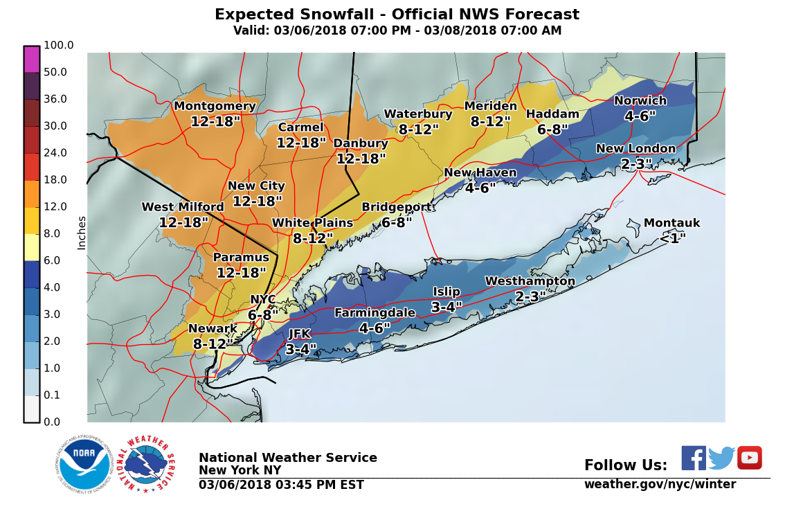
The storm is tracking very close to shore on the means of all the major models now, but the components broken down still spread over a wide reach.
While the potential for bust is there, I think the gradient will be steep from the coast inland. Long Island will see rain, the Jersey shore a mix, and we will see a mix but leaning towards snow. I still think this is overall cold enough both at the ground and mid levels, and wet enough with 1.00" to 1.50" of water (QPF) that 8 - 10" of snow, probably wet and probably mixed at some point with rain and/or sleet, is very likely.Forecast: Winter Storm Warning per NWS. Light snow or rain develops this evening or later tonight, changing to all snow in MAPSO by daybreak. 1 - 3" possible overnight.
When the precipitation becomes heavier, probably around noon or one, it will change to all snow if there is any rain still happening. Snow, heavy at times, for the rest of the day. This is why they closed school. Don't go by what you see on the ground when you wake up, it is what is likely to be happening at dismissal time that has the district worried.
If banding sets up, we could see periods of 1 - 2" per hour in the afternoon and evening. If so, expect 10+" more snow for a 12"+ total. Without those heavier squalls, more likely to see 6 - 8" total.
The other thing that could bring the totals down is a change over back to rain, or a dry slot moving in. Neither thing can be forecast at this time but the possibility exists. This could also knock an inch or three off the total.
Precipitation should end by midnight Wednesday night.
There is no point in trying to over analyze this storm any more tonight. I do not think the models are going to get a better handle on things before we turn to nowcasting in the morning: looking at radar and actual storm formation. This is one of those times I feel sorry for real meteorologists. I get to throw my hands up and say, this one is above my pay grade!

Klinker said:
als4532 said:
F that. I flew back from Austin a day early missing out on a conference I was excited to attend in order to avoid being trapped there so it better get Pleistocene out here.
oots said:
im all for the bust
Trapped in Austin? Don't tell me, they were going to force you to eat delicious BBQ, drink Shiner and shop at Book People.
I'm gong to drink Shiner right here in Maplewood, if that helps.

So it could have the potential for 6 inches in Maplewood, but 10 inches a bit further west depending on where the rain/snow line sets up? Wondering about how far the NJ transit trains will make it west tomorrow

Anyone want to wager on the odds of Hunter College being closed tomorrow (upper Eastside in Manhattan)? 
- Alex

I want it all. At least a foot. With everything that cancelled, let's at least make it worth it.
campbell29 said:
So it could have the potential for 6 inches in Maplewood, but 10 inches a bit further west depending on where the rain/snow line sets up? Wondering about how far the NJ transit trains will make it west tomorrow
To be clear, I expect 8 - 10" in Maplewood, but there is a wide potential for other outcomes in other places.
The problem wasn't being trapped in Austin, it was being trapped. I would have loved to stay, but I couldn't stay any longer than I was going to be there, family, work, etc. So, I'm pissed I'm no longer there.
Klinker said:
als4532 said:
F that. I flew back from Austin a day early missing out on a conference I was excited to attend in order to avoid being trapped there so it better get Pleistocene out here.
oots said:
im all for the bust
Trapped in Austin? Don't tell me, they were going to force you to eat delicious BBQ, drink Shiner and shop at Book People.

This is easily one of the most difficult storms to forecast snowfall I've ever experienced. Theres a lot of variables that are creating an absolute operational forecasting nightmare. I don't envy the NWS forecasters one bit tonight. Here are some of my thoughts:
1. From a large scale perspective, the placement of the low is absolutely key. At this point in the season, the temperature of the total atmospheric column is usually the make or break when it comes to the character of the snowfall. The further east the low gets, the more cold air can funnel into the region and the higher snow totals will be in general. Tonights NAM shifted the low slightly south and east versus this morning and this afternoon's runs. That slight shift could make a really big difference in keeping column temperature cooler and thus more optimal for snow production. The placement also impacts where that (larger scale) snow gradient sets up. The fact that its further east likely shifts the snow gradient further east as well, and would likely increase totals across MSO. If the low wobbles back west (east) in future runs, expect decreased (increased) totals in subsequent forecasts.
2. Easily the biggest challenge in situations like this however is the placement of the heavier, banded precipitation associated with what are known as "deformation bands". Deformation bands are areas where the wind field is deformed from more uniform to one that is stretched along an axis (think taking a square shape and stretching it along an axis so that it deforms to a rectangle). When you have a deformation band set up, it increases the convergence of air in that region which results in enhanced upward vertical motion. With that, heavier snowfall rates are nearly a guarantee. The forecasting challenge here is that these bands are very, very small in scale. When we look at forecast models, they calculate the wind/temp/moisture/etc. at specific points on a grid. The spacing of those points is known as the resolution, and the closer the points are to one another the higher the resolution. The problem is that often times these very small scale (mesoscale) features fall in between grid points, and they have to be approximated. Due to this, figuring out the exact location of the bands, and the resultant enhanced snowfall is nearly impossible. What we do know is that there is an expectation that strong deformation will occur over Northern NJ in association with frontogenesis (the development of a front), and someone will likely get clobbered. Who that is remains to be seen.
3. A final little cherry on the top is that in association with the increased frontogenesis much of the strong vertical motion will occur within a layer of the atmosphere that is characterized by temperatures between -10 and -20ºC. This layer is known as the "dendritic growth zone" (DGZ) and is a layer in which extremely efficient snow production takes place. Whenever you see really intense vertical motion within the DGZ, you can expect a rather robust snow event. Some of the vertical profiles of the atmosphere tomorrow are pretty wild in terms of the vertical motion within the DGZ, so I'd expect spurts where pretty giant snowflakes, known as dendrites, fall out of the sky. Dendrites are also the really pretty star-shaped snowflakes. As if that weren't enough, I'd say thundersnow is also a realistic possibility given the upward vertical motion likely present.
So what's the takeaway? I think that 8 inches is likely a decent median snowfall amount over the general area, but I wouldn't be surprised if there were very localized areas with significantly more snowfall even than that. The nearly if not completely impossible challenge however is figuring out exactly where that will be, and our modeling capabilities will likely never be able to perfectly forecast the precise locations of the highest snowfall totals. For that reason, I'd also steer clear of many of the forecast snow maps that people post on social media that come straight out of models. Different models are tuned for different situations, and many of the assumptions that get made within them completely determine the snowfall totals that they spit out.
I wish I were in Maplewood for this. Will be back Thursday. Because of course.

I'm tempted to scream "I want the truth!" To which any one can yell back "You can't handle the truth!"


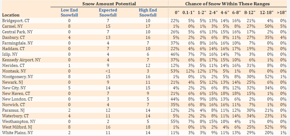
Our chance of 0" went from 10% to 21%. Chance of 8" and above went from 50% to 31%. (using Newark)
als4532 said:
The problem wasn't being trapped in Austin, it was being trapped. I would have loved to stay, but I couldn't stay any longer than I was going to be there, family, work, etc. So, I'm pissed I'm no longer there.
You missed an absolutely gorgeous day AND an exciting primary election.

No on street parking due to the snow emergency. I get that. However, we don't have a driveway, and my husband needs to have his car accessible to get to work tomorrow morning, and I'm sure our neighbors don't want to hear a snow blower at 5am while he's digging the car out, so he needs to park it at the end of our neighbor's driveway tonight as she was very generous in allowing us to block her driveway with our car so he can get out without digging out the whole 75'. We have to wait for our neighbor to get home to do this, but when I called to ask for permission, I was told they can't give it to me. I'm not asking for overnight, I'm just asking to be allowed to keep the car on the street until 1am. There is literally not one single snowflake on the ground yet.
I don't blame the person on the phone. I blame the brass at MPD for being so inflexible. Again, I'm not asking for permission for overnight, I'm just asking that I be allowed to wait until 1 at a time when the snow has not yet started.

Meh, some slight sticking on the grass, but not much else. I'm hoping it stays like this until at least 6:30 so my husband doesn't have too much of an issue getting into work. For the most part having a light little car is great, good gas mileage and all that. But when there's a lot of snow on the roads having something a little heavier and with 4WD is a plus, which we haven't had.

I cleaned about half an inch of wet snow off my car at 4:50 and had an easy drive to EWR. The roads are wet but not much else right now.
I'm sure flights later will be a mess.
Forecast is on track with a slight tick to the east this morning. We are currently just on the rain side of the line, but as wind and precipitation pick up over the next couple of hours expect changeover to all snow.
As wxnut explained above, a lot has to do with where the smaller sub-systems, the bands, set up. If we dodge the bands, 8-10". But a band swinging through is another 1-3" on top, with those 1-3" falling in an hour or less. No way to forecast those, too small for the models to see, unless you watch the radar and 'nowcast' it.
Wind about 20mph steady throughout the day, with possible gusts into the low 30s, so about half of Friday's wind. The higher winds you are hearing about are going to be east of here. There is a slight chance of thundersnow if a band sets up. Worst of the gusts should be over by early afternoon.
Snow ending after sunset.
So what is the prediction for getting home from the city late this evening around 10 pm? Trains look to be running limited right now though the weather's not bad yet.
Of any appreciable snowfall.
max_weisenfeld said:
yahooyahoo said:
Sooooo you're saying there's (still) a chance?
Of what?


Not according to his latest Facebook post. Things should really start happening around 11 this morning.
more a likelihood then a chance
yahooyahoo said:
Of any appreciable snowfall.
max_weisenfeld said:
yahooyahoo said:
Sooooo you're saying there's (still) a chance?
Of what?

I understand that there is still a likelihood of appreciable snowfall once the heavier bands reach us in the next half hour or so. Question is whether the accumulation of that snowfall on sidewalks and roadways is apt to be less than predicted since we are this far into the storm with little or no accummulation.
ETA: Based the chart Jamie's posted above, there is a 50% chance of 6 inches or less of snow accumulation in the Newark area.
I have a friend landing in Newark at 3:30 from Amsterdam - I was surprised the plane took off on time. May be tough getting from the airport to Maplewood - we will see.
Sponsored Business


Promote your business here - Businesses get highlighted throughout the site and you can add a deal.


im all for the bust