Winter Storm Wednesday 3/7

From last night's forecast:
max_weisenfeld said:
When the precipitation becomes heavier, probably around noon or one, it will change to all snow if there is any rain still happening. Snow, heavy at times, for the rest of the day. This is why they closed school. Don't go by what you see on the ground when you wake up, it is what is likely to be happening at dismissal time that has the district worried.
If banding sets up, we could see periods of 1 - 2" per hour in the afternoon and evening. If so, expect 10+" more snow for a 12"+ total. Without those heavier squalls, more likely to see 6 - 8" total.
The other thing that could bring the totals down is a change over back to rain, or a dry slot moving in. Neither thing can be forecast at this time but the possibility exists. This could also knock an inch or three off the total.
Still standing by this.
There is a deformation band setting up south of Philly and headed our way.


I flew home from Naples, fl. late last night so I wouldn’t get trapped there. I’m starting to regret that.

that doesn’t sound like the right move! Trapped in Naples in the sun sounds like a better choice!

National Weather Service just doubled down.
They are increasing their forecast snowfall for our area to 12 - 18"


max_weisenfeld said:
National Weather Service just doubled down.
They are increasing their forecast snowfall for our area to 12 - 18"
Ohhhhh, ****! I was just starting to get excited about a bust.

Naples, ugh. High rises, strip malls, condos, concrete jungle with crowds and crowds of people on beaches and everywhere, with a few palm trees sprinkled in. Don’t go in sun these days anyway. I prefer snow!

Oh no! Schools calling for another snow day seems likely which means we'll have to take a day from our spring break in my district.
max_weisenfeld said:
National Weather Service just doubled down.
They are increasing their forecast snowfall for our area to 12 - 18"
mbaldwin said:
max_weisenfeld said:
National Weather Service just doubled down.
They are increasing their forecast snowfall for our area to 12 - 18"
Ohhhhh, ****! I was just starting to get excited about a bust.
I was excited about a deformation band (good name for a group.)
I don't care how much snow we get as long as we don't lose power. Lost it again last night for a few hours (third time since Friday.)


that big central NJ band looks to be pivoting north west, I wouldn’t expect that to be the main player in Maplewood today. I *think* that may be sort of a pseudo warm-front, but very unsure of that.
Looks pretty rich right now -- dendrites, <1/8 mile visibility, and the temp dropped 1 degree F in ten minutes just now.

12:30 and I can still see grass on my lawn. If this storm wants to dump 12-18 inches it needs to get going.


max_weisenfeld said:
From last night's forecast:
max_weisenfeld said:
When the precipitation becomes heavier, probably around noon or one, it will change to all snow if there is any rain still happening. Snow, heavy at times, for the rest of the day. This is why they closed school. Don't go by what you see on the ground when you wake up, it is what is likely to be happening at dismissal time that has the district worried.
Still standing by this.
And it's right on time! 
Looking at some real time analysis, there is strong deformation occurring over a deep vertical layer indicative of frontogenesis. In addition that, the environment appears primed along the band for the release of "slantwise instability", which is well known to occur in areas of banded precip like that, but can also help to rapidly increase the intensification rate of the storm itself. So I'd be on the lookout for at lease some more intensification of this thing. As for that band, the more I look the more I think it may be a bent back warm-front, especially given the deeper-upright convection to its east, and that the frontogenesis function is sloping in such a manner consistent with a warm front.


Time for driving is over, kids. Took dog to park to squeeze in a visit before it got bad. Road was tolerable on way there around 12:30 but on way back, got scary. Someone was already stuck on uphill side of SO Avenue.

I have a Ouija board. It is a close relative to one of those little black 8 balls used to predict the future
When I ask it if this storm will give us a major snow accumulation, it answers " It's a possibility"

mem said:
Naples, ugh. High rises, strip malls, condos, concrete jungle with crowds and crowds of people on beaches and everywhere, with a few palm trees sprinkled in. Don’t go in sun these days anyway. I prefer snow!
Next year instead of Naples come visit us in St Pete. January is too cold to swim but March is fabulous. I wish I was there now.


I heard it as well. And now I can not get AC/DC's "Thunder Struck" out of my head.

Just got past a guy on Ward Place who couldn't make it up the slight hill from S.O. Ave. onto Ward.
Sarah, it was a business trip, but next time I’ll extend and go spend time with you guys, cheers!
it is GORGEOUS outside! That said, the trees all have VERY thick, heavy snow weighing them down, which is going to be dangerous for kids playing under them. Be safe!
Rentals
For Sale
-
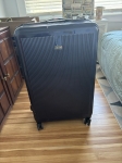
REVO luggage $100
More info


Garage Sales
-
House Contents Sale Sale Date: May 18, 2024
More info

I would think starting so late saved us from getting over 15 inches. I will take 6 inches or so at this point.